|
The Waubonsie Trail
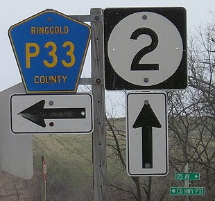
Present Day State Highway 2
 The Iowa State Highway Commission under the 1913 Iowa Highway Route Registration Act required routes of 25 miles or more in length be registered. The Iowa State Highway Commission was given the authority to determine which road association would be granted permission to use of the route names, and color combinations and designs of the route markings. The registration process continued through 1924. There were 64 routes registered with the Iowa State Highway Commission during this period.
Named after Pottawattamie Chief WAUBONSIE who
died in 1844, registration of the Waubonsie Trail was set in motion on January 2, 1914. Mount Ayr attorney H. C. BEARD, supporter of the good roads movement, requested the required application forms from the Iowa State Highway Commission, asking that they be sent to the president of the Waubonsie Trail Assocation, U. G. REINENGER of Sioux Falls, South Dakota. There was a five-dollar fee for filing the application. The Waubonsie Trail Assocation elected new officers in November of 1914 with C. F. MITCHELL, president; Charles WENSTRAND, secretary; H. J. ROSS, treasurer; and, H. C. BEARD, vice-president. In 1915, the county boards were advised to appropriated at lease $30 per mile for dragging the roads. The Waubonsie Trail in Iowa covered 289 miles [92 miles in Iowa] and was registered on April 3, 1916. This historic trail was named after Chief Waubonsie of the Pottawattamie tribe who was an important negotiator in the Treaty of the Wabash in 1826, the Treaty of Chicago in 1831, and the transfer of some 5 million acres of Pottawattamie land in Iowa. When Chief Waubonsie and the Pottawattamie Indians were forced from Illinois to Kansas, they traveled through Iowa, starting in Keokuk along the Mississippi River and continued across Lee County to Van Buren, Davis, Appanoose, Wayne, Decatur, Ringgold, Taylor, Page, and Fremont counties. This pathway became known as the Waubonsie Trail, named in honor of their chief. Waubonsie Trail through Ringgold County became the Lesanville Road, then Primary Road No. 3 in the 1920's. When the road was paved in the 1940's it became Iowa State Highway 2, the name it bears to the present day. SOURCE: www.iowadot.gov/.../autoroutes_registered.htm
Decatur County Journal
Leon, Decatur County, Iowa
Thursday, March 9, 1911
WAUBONSIE TRAIL
The Waubonsie Trail matter has so livened up things in this section that another trail association has been organized and is promoting a trail to run from Des Moines to St. Joseph and Kansas City by the way of Leon, Lamoni, Eagleville and Bethany. The matter was started at just about the same time by the boosters of Leon and the boosters of Lamoni. Leon had talked over the matter and was quietly getting things in shape for the launching of the scheme when Lamoni organized and the Leon people have entered into an agreement to let the preliminary organization made at Lamoni Wednesday of last week stand, and working with representatives from Harrison County, Mo., will push the work of organizing the other counties in both states along the proposed route of the new trail.
The name of the trail was officially chosen at the Lamoni meeting. It is to be called the "Des Moines, Kansas City and St. Joseph Inter-state Trail association." W.A. HOPKINS was chosen president; J. C. DANIELSON, vice president; Dan ANDERSON, secretary and G. W. BLAIR, treasurer. These officers will remain in office until the annual election, which will be provided for in the constitution, is held. The headquarters of the association will be located at the town of Lamoni. The object of the new trail organization is to promote and maintain an improved highway on north from Des Moines indefinitely and from Des Moines south by the way of Indianola, Osceola, Leon, Lamoni, Eagleville and Bethany. There will be a junction trail at Bethany, one of them traversing the route from Bethany to Pattonsburg, Cameron and Kansas City and the other running west and south to Albany, King City and St. Joseph. The routes are so arranged as to give the shortest possible mileage between Kansas City, St. Joseph and Des Moines. This road or trail will connect the principal cities in this section and should and will without the least doubt prove a most popular route of travel for automobiles and other methods of travel. The proposed trail gives a direct route from Fort Leavenworth, Kansas, to Fort Des Moines. This would be of great advantage in the movement of government troops.
Representatives from Lamoni were in Leon Monday meeting with the committee from the Leon Commercial club **(part of article missing)** the route of the road who become members of the association, also the location of their farms. The folder will be similar in form and general style to those issued by railroads and will be placed in hotels of the terminal cities and also in those of the towns along the trail. The Commercial clubs of the various towns will be given an opportunity to place advertising matter in the folder setting forth such facts regarding their cities and surroundings as they desire to announce to the public, also views of points that may interest tourists and prove of benefit to the cities and towns. The trail association will make every effort to have the road placed in the best possible condition and induce the counties through which the road passes, to construct permanent concrete bridges and culverts. It is expected that the farmers will keep their part of the road dragged and worked into proper condition. Each town will be responsible for the road half way to the next town on the trail. All of this work is to be done under the direction of the local trustees in each county and the executive board.
Already the work of organizing two counties, Decatur County, Iowa, and Harrison County, Missouri, has been completed the trustees for Decatur County being Jas. F. HARVEY and Jas. W. HURST, of Leon, P. E. SHIRLEY, of Davis City, W. A. GRENAWALT and Dr. W. J. MATHER, of Lamoni. In Harrison County, Missouri, the trustees are E. H. FRISBY, B. P. SIGLER and Leonard HEASTON, of Bethany, O. W. CURRY and R. A. HART, of Eagleville. The work of organizing the other counties along the proposed route will be pushed forward vigorously. The route from Leon to Davis City, Lamoni, Eagleville and Bethany, a distance of forty-four miles has been located and the trail will be continued in both directions from Leon and Bethany.
This trail, or improved highway, will indeed prove a splendid thing for this section and the state at large. It will connect with the Wabonsie Trail in Decatur County and thus afford another trail running east and west through the southern tier of Iowa counties. At Des Moines it will consist with the famous river to river road and also the Des Moines and Lake Okoboji roads. The cities and towns and farmers will be greatly benefited. At all points where the matter of the trail has been taken up with the people, all, especially the farmers, are enthusiastic and have promised their hearty support.
~ ~ ~ ~Decatur County Journal
Leon, Decatur County, Iowa
March 11, 1911 WAUBONSIE TRAIL
Waubonsie's Trail is mapped across the state and now forms a tie that binds Keokuk on the east to Nebraska City on the west, marking the line that Mr. REININGER, president of the Trail Association, says will eventually become the first hard road crossing the state of Iowa. Beginning at the Missouri river on the west, the counties and towns traversed by Waubonsie's Trail are the following:
Fremont County: East Nebraska City and Sidney, the county seat. Page County: Shenandoah and Clarinda, the latter the county seat.
Taylor County: New Market, Gravity, Conway, with Bedford the county seat, being reached by a well kept road connecting either at Gravity or New Market.
Ringgold County: Benton, Mt. Ayr, the county seat, and Kellerton. Decatur County: Leon, the county seat, Lamoni, Davis City and High Point.
Wayne County: Corydon, the county seat, Bridgewater and Promise City, with a good connecting road to Seymour only three miles off the trail.
Appanoose County: Jerome, Centerville, the county seat, and Moulton. Davis County: Westgrove, Bloomfield, the county seat, and Pulaski.
Van Buren County: Milton, Cantril, Mt. Sterling and Farmington, with a road connecting Keosauqua, the county seat, from Mt. Sterling and Farmington.
Lee County: The road runs nearly due east from Farmington to a point south of Donnellson, where it connects with a stretch of macademized road that leads into Keokuk, the eastern terminus and the largest city on the Trail. Waubonsie's Trail is by many miles the shortest across the state, and being the only defined road crossing the southern portion of the state, will soon prove one of the most popular. Road work is now under way in nearly all of the counties and the promises of voluntary assistance and help are surprisingly large. It means a great, broad highway that will prove as prominent as the milky way across an autumn heaven.
Transcriptions by Sharon R. Becker, September of 2017


|