|
Cherokee
county, Iowa, lies in the northwestern part of the present State of
Iowa. It is within the Missouri River Basin and, in terms of topography
and climate, lies in the transition zone between the woodland prairies
and the high plains. The area was acquired from the Sioux Indians by
treaty in 1850.
In 1851, the Iowa General Assembly created a number of counties in a
newly surveyed North West Iowa. The counties created by the legislature
were given the names of famous men, Indian tribes, and battles;
apparently at the whim of the legislators. Cherokee county was named
for the Cherokee Indians; who actually lived in the southeastern U.S.,
and later in Oklahoma. At that time, there were no permanent white
residents in the county. The county, as created, consisted of 16
congressional townships of 36 sections each - an area of 576 square
miles. For governmental purposes, it was attached to Crawford County.
In 1853, it was attached to Wahkaw (Woodbury) County and was known as
Cherokee Civil Township of Wahkaw County. In 1858, Cherokee County was
officially organized as a county, with a single civil township. Today
the county has 16 townships, which are as follows: Spring, Cedar,
Liberty, Marcus, Amherst, Sheridan, Cherokee Afton, Pitcher, Pilot,
Rock, Tilden, Grand Meadow, Willow, Silver and Diamond.
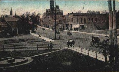
The principal cities and towns are: Cherokee - the county seat,
Aurelia, Cleghorn, Larrabee, Marcus, Meriden, Quimby and Washta.
|
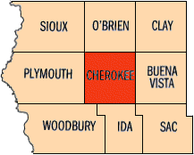
Cherokee County's Neighboring Counties
|
|