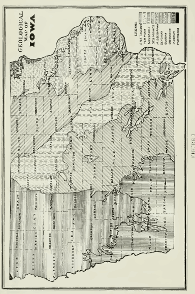
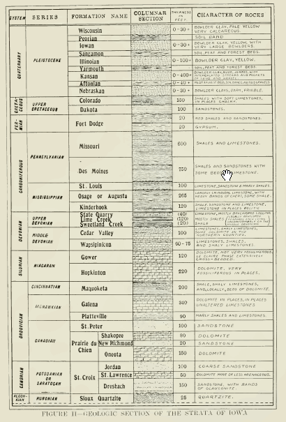
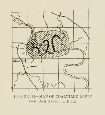
Near Coalville the coal lies in three horizons the lowest of which is a cannel coal. The "Pig Coal" of this region seems to have been laid down in the deserted
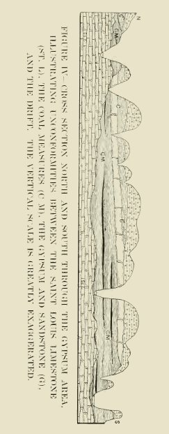
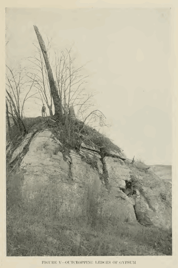
HISTORY OF WEBSTER COUNTY 5 channel of an ancient river, as it is confined to a very narrow strip of which the center lies much lower and is thicker than the marginal portions. The can- nel coal has a somewhat lower fuel value than good bituminous coal, because it contains more gas and less carbon. It is very fine-grained and may have had a slightly dift'erent origin than the other coals. Elsewhere in Iowa there is a still greater alternation of coal and shale, while in some parts of America the number of seams is astonishingly large. Thus in the Xova Scotia field there are seventy-six distinct seams, each one of which speaks of a repetition of the series of events outlined above. These conditions speak to us of a period when plant life flourished on the iXmerican continent, and elsewhere also, in such profusion as it had never reached before. Coal swamps covered thousands of square miles between Xova Scotia and Oklahoma. We need not think of Des Moines time as being a period of tropical climate, for the evidence points rather to a climate of moderate temperatures, considerable moisture and great uniformity both as regards seasons and areas. This is shown bv the similarity of plant life of the period from Greenland to Brazil. Although the coal beds form only a small part of the strata of the Des Moines stage, or Lower Coal Measures, of Webster county, they are a very important part. The mining of the coal from these beds forms one of the county's impor- tant industries and indeed forms the basis of much of the industrial life of the community. Owing to its strategic position as the most northerly coal produc- ing area in the state, mining was early pursued in Webster county. The state census of 1862 credits the county with an output of 250 bushels and the federal census of 1870 showed that an output of 34,400 tons placed Webster as the fourth producing county in the state. The production has risen as high as 140,000 tons, which figure was reached in 1902. Since then there has been a decline due to the working out of the best seams. The output for 1910 was 49,973 tons valued at $111,720. The early settlers knew of the presence of coal and in 1870 Mr. J. L. Piatt, Hon. J. F. Duncombe and others opened the first shipping mine in the county. This was located on Holaday creek, and about three miles from the Dubuque and Sioux City, now the Illinois Central, railroad, with which it was connected by a tramway. Other mines were opened in the next few years and the building of other railroads gave an added impetus to the industry. Coalville. Kalo and Lehigh have been important districts from the beginning of operations until the present. Following the deposition of the Des Moines beds came a time when the sea seems to have covered southwestern Iowa more continuously and the shales and limestones of the iMissouri stage or Upper Coal Measures, were laid down. There are one or two thin seams of coal accompanying these beds, but they are not so important as are the coals of the Lower Coal Measures. W^e do not know that the Missouri sea ever covered Webster county and so this county in common with eastern and northern Iowa was doubtless a land surface, and as such was subjected to all the changes which the erosive forces of Nature could produce. That these forces were active is sliown by the irregularity of the con- tact between the Des Moines and the overlying beds as will be described below. It has been stated that the shore-lines of the ancient seas across Iowa were gradually retreating toward the southwest. The Des Moines ocean formed an 6 HISTORY OF WEBSTER COUNTY exception to this as it overspread the most easterly known Hmit of the Saint Louis beds in Webster county and far to the southeast. The Missouri sea, how- ever, seems to have followed the rule, as we know of no beds of this age east of a line drawn, say, from Guthrie Center to Corydon. But when the sea again invaded Iowa it far surpassed the bounds of the Missouri stage and indeed reached nearly to the present limits of the Des Moines beds. This was the. Permian ocean and the Permian period is of especial interest to us because only in Webster county are its strata known — namely the gypsum beds and their associated shales and sandstones. Permian strata may, of course, underlie the younger rocks of the northern and western counties, but their presence there has not been positively determined. The nearest known rocks of this age are in southeastern Nebraska and Kansas. Gypsum beds like salt deposits indicate an arid climate. So we know that during Permian times the shallow ocean was very much reduced and that lagoons and lakes were formed in which the gypsum beds of Webster county, and of Texas and Oklahoma, and the salt and gypsum of Kansas accumulated. We may surmise that chmatic conditions in Webster county were quite similar to those now existing in southwestern United States with the addition of this bitter lake from the waters of which gypsum was being precipitated. The lake extended in a northeast-southwest direction across the county, centering at Fort Dodge, and in it was formed a bed of remarkably pure gypsum varying from ten to thirty feet in thickness. Thin clay seams interbedded with the gyp- sum may indicate incursions of the sea, letting in ocean waters, from which were precipitated other layers of gypsum. Then finally there came a more extensive inundation, accompanied by the deposition of red shales and sandstones, which overlie the gypsum and are spread over a greater area than that covered by it. This was not the first time that such conditions had existed in Iowa, for in drilling the deep well at Greenwood Park. Des Moines, thin layers of gypsum were found in the Silurian rocks and during the year 1911 a bed varying in thickness up to eighteen feet v.as discovered in the Saint Louis limestone at Centerville in southeastern Iowa. After the Permian there was another long time when Webster county was dry land. This is represented in the chart by the wavy line above the beds of the Fort Dodge stage. So far as now known all of Iowa was dry land during this period. Could -we have seen our state during those days it would probably have presented a different aspect from that familiar to us today. Although tremendous changes were in progress elsewhere, as for instance the forming of the Appalachian mountains in the east and the Ouachita mountains of Arkansas, there was but little movement of the earth's surface in ovir own area — simply an elevation sufficient to drain ofif the ocean. It is not likely that our present river systems had been developed at that time and so the land was drained by a system of streams which is now doubtless largely, if not entirely extinct. The plant life of the time was similar to that of the coal periods. Gigan- tic ferns, cone-bearers, and other allied genera formed the forests. There were no flowering plants nor grasses. These did not appear in America until long afterwards. The animals of this time resembled in their lower forms the older types but there was a gradual transition to more modern forms. One of the
HISTORY OF WEBSTER COUNTY 7 most notable features of this transition was the great development of true reptiles. So notalile is this development that the period is known as the Age of Reptiles. The mammals and birds also began their rise during this time although they did not become prominent until later. We have no remains of the life of this period in Iowa as there were no deposits formed in which these remains might be preserved. But that progress was taking place here as elsewhere there can be no doubt and hence the events and life forms mentioned form a vital part of Webster county's history. In course of time there occurred one of the greatest transgressions of the sea over Xorth America that is known in all geologic history. Just prior to this incursion the Dakota sandstone had been laid down in a series of extensive fresh-water lakes. Then the Great Plains were submerged and western Iowa suffered the same fate. The eastern shore-line was somewhere in the region of Webster county and probably some of the county formed part of the ocean floor. On this floor — the floor of the Upper Cretaceous sea — were laid down the chalky limestones and shales of the Colorado stage. Over the great plains the Dakota sandstone forms an artesian reservoir, and the chalks and shales of the Colorado are used in many places for the manufacture of Portland cement and clay wares. This was the last time that the ocean invaded Iowa and in all the centuries upon centuries which have succeeded the Cretaceotis period the state has been a part of the constantly growing continental nucleus. Through much, perhaps the greater part, of the history which we have outlined, thebuilding-up processes had been busy in Webster county. But- from this time forward the activities and changes were to be those which tend, toward the tearing down and carrying away of the piled-up masses of rock. To this a partial exception must be made of the events of the Pleistocene epoch. During this long gap in the geological record of Webster county the climate was mild and pleasant and the life forms were approaching gradually those familiar to us today. But with the beginning of the Pleistocene there was a change in conditions. For reasons not yet fully understood the climate of the northern hemisphere underwent a; gradual change. Instead of the long warm sinnmers of preceding epochs there came a time when the stimmers were shorter and cooler. In Canada the snow accumulated from year to year and finally began to creep, as solid ice-fields, over the sunny plains of the northern states. By and by these ice-fields overwhelmed Webster county and swept far to the south as the Nebraskan glacier. As this glacier marched slowly but irresistibly southward it gathered into itself the loose stones, clay and sand and other material which had accumulated from ages of rock weathering. With these as its tools it graved and scoured and wore away the underlying rocks. It carried along its miscellaneous load in its all-enveloping mass and when at last it was melted away this material was left as a great sheet of till or glacial drift spread alike over hill and vale. The eft'ect of this sheet of till, added to that o£ the cutting down of the higher points in the topography, would be to produce a level, even landscape, probably very similar to that which characterizes Webster county's prairies today. Upon this landscape, then, the streams began to incise their valleys. The Des Moines river had probably been at work liefore the Xe- l)raskan glacier came down and the flowing waters again sought and cleared out 8 HISTORY OF WEBSTER COUNTY the old channel. Forests grew and grasses waved where only fields of ice had been and Webster county emerged into the pleasant summer-time of the Afton- ian interglacial age. The animal life of the time constitutes one of its most remarkable features. Elephants, mastodons and sloths roamed the forests and plains. The bison, the camel and the horse were familiar neighbors, and the deer, the bear and the wolf were then as now hereditary enemies. It has been only within the last two or three years that studies in western Iowa have proved the presence in abundance of these long-departed wanderers by prairie and stream. After a time there came a recurrence of those climatic conditions which had caused the first glaciation and once more the ice-sheets crept slowly down from the northland. Forest and prairie were again hidden beneath the frozen mantle and life of all kinds was wiped out or driven southward. This was the Kansan glacier and today the burden it bore forms the surface till over south- ern and western Iowa. As the years passed the climate again moderated, the ice melted away and Webster county again lay open to the smiles of the warm sun. The next glacier which entered the Mississippi valley — the Illinoian — came from the east and only its fringe crossed the Father of Waters into Iowa, covering a narrow belt between Clinton and Keokuk. So during the long, long centuries marked by the passage of the Yarmouth inter-glacial interval, the Illinoian glacial stage and the Sangamon interval, Webster county was experiencing the maturing of her topographic features which always goes on when Nature has a change to set her erosive forces in operation. During the long cold winter of the Illinoian. although there was no ice-sheet in the county, the heavy snows would cover the land with their white mantle and arctic conditions would prevail. These conditions may have recurred during the lowan glacial stage also, for it is not very probable that the ice-sheet of this age extended so far westward. It seems to have been a small lobe of ice covering only the northeast part of the state, east of Clear Lake and north of Iowa river. In this case we shall have to extend to the end of the Peorian interval the time while Webster county was open to the influences of summer sun and winter snows. We have but scant means of judging the length of these glacial and inter- glacial ages. We know from present-day studies how slowly the glaciers of the world move and how slightly they change from century to century. So we may know that centuries and milleniums unnumbered have rolled by since first the great continental ice-sheet swept down from its northern home. It has been estimated from studies of the dififerent drift sheets of the Mississippi valley that if the time since the retreat of the last ice-sheet be considered as unity the length of time since the close of the Kansan invasion must be reckoned as fifteen to seventeen. To this must be added again the length of Kansan time itself as well as that of the Aftonian interglacial age and of the Nebraskan invasion. We know so little of this latter that we are not yet in a position to place any estimate upon its duration or antiquity. The streams and rains and winds had worked for countless years upon the rocks and soils of Webster county when again the climate changed and another period of intense cold ensued. The drift sheets of former invasions seem to have been very largely worn away during this interval and deep valleys had
HISTORY OF WEBSTER COUNTY 9 been cut in the sandstones and shales and gypsum beds so that wherever the loose mantle rock is removed the surface of these underlying rocks is rough and irregu- lar. When the Wisconsin glacier came into our county it plowed over the rem- nants of old till, gathered up such rock fragments as it found loose on the surface or could pluck from their parent ledges and mixed and ground all this load in its mighty mills and finally left it spread out as the rich productive soils which make Webster county's farms a veritable treasure-house. All the ele- ments of soil fertility and plant food are found in these glacial clays and, enriched by generations of vegetable growths, they are unexcelled among the soils of the state. It is a common saying, though none the less a true one, that our soils are the basis of our wealth and our social welfare. Upon this founda- tion we may rear the superstructure of great manufactures and extensive com- merce ; but where the foundation is poor or lacking the superstructure is impos- sible. It should require but little urging to show the intelligent farmer how carefully he should guard his priceless heritage, with what appreciation he should receive Nature's bountiful gifts. Since the departure of the Wisconsin ice there have been no other advances of continental glaciers. The ice-fields of Canada have dwindled and gone ; only in Greenland is there any accumulation of ice in the northern hemisphere that is at all comparable to the glaciers of the Pleistocene. Whether we are living today in true post-glacial times or merely in an interglacial interval only the future can reveal. It seems incredible to us that the monuments of our civilization should ever be destroyed by the relentless push and grind of a con- tinental glacier, but we cannot well measure the mighty sweep of world-building by our tiny span of human achievement. In addition to the coal mining industry there are two others in Webster county which are dependent upon the mineral resources of the county. These are the gypsum plaster and the clay-ware industries. In the first of these, as already indicated, this county is unique among the counties of Iowa. It has developed since the building of the first mill in 1872 until at the present time it places Iowa among the leaders in this industry. In 1910 there were mined 322,713 tons of crude gypsum and the various products made from this were valued at $943,849. The history and development of this industry will be traced elsewhere and need not be recounted here. The great clay-shale deposits of the Coal Measures furnish the basis of another industry in which Webster takes high rank among the counties of the state. Drain tile, hollow building block, common and pressed brick, all of excel- lent quality, are made from these shales. The necessity for artificial drainage over much of the county has given an impetus to the manufacture of drain tile which makes it the most important branch of a large and growing industry. This is shown by the fact that during 1910 to the valuation of $976,266 placed upon the clay wares produced in the county, the drain tile makers contributed a quota of $668,445. With the development of scientific agriculture, and of scientific building it may be added, when greater care shall be taken in building homes and industrial structures of fireproof materials, there is certain to be a still larger growth of Webster county's clay industry. 10 HISTORY OF WEBSTER COUNTY TOPOGRAPHY It doubtless has been made clear in the preceding paragraphs that the topog- raphy of a region is dependent upon its geological structure in combination with the history of the forces which have been acting upon it. In a district which is so heavily blanketed with glacial debris as is Webster county the structure of the underlying bedded rocks is entirely masked except where these are exposed by stream erosion. Tiien too. the time which has passed since the Wisconsin ice spread out its sheet of till has been so short that, if we except the immediate valleys of Des Moines river and its tributaries, the erosive agencies have scarcely begun to be effective in carving relief forms in the level Wisconsin plains. And so the result is that Webster county has what may be called a glacial topography as contrasted with an erosional topography, that is. one produced by the action of running water, frost and heat. There are two types of glacial topography, the flat even plain, and the irregular jumbled hills which rise from the surrounding plain but usually bear no close relation to the natural drainage lines. Both of these types are represented in Webster county, although the plains type is by far the more important. As the glacier melted away the natural tendency was for the load it carried to be spread out quite evenly, but at the edge of the ice, where the forward movement was balanced by melting, the clay, stones, gravel and such material carried or pushed along would be dumped in great mounds. So here and there over the glaciated region we find these mounds and ridges, here arranged in long series, there without any arrangement whatever. Such ridges are quite common in the northwest part of the county, most of them west of the Des Moines and north of South Lizard creek, although some are found elsewhere, and one. Coon Mound. east of Cowrie, is miles from any simi- lar hills. Some of these piled-up hills are built largely of sand and gravel since the finer clay was washed away by water from the melting ice. These form today almost exhaustless supplies for all the purposes for which such materials are used. The traveler along the Minneapolis and Saint Louis railroad from Tara southward may gain an excellent idea of the typical Wisconsin plain topography. While Lizard creek has a fairly deep valley the landscape for the most part is so level that one village may be seen from the next, and from Moorland and Cal- lender the great gypsum mills east of Fort Dodge are plainly visible. Railroads are a good index of topography and the long straight line of the Minneapolis and Saint Louis, with scarcely a curve between Tara and Cowrie, bespeaks a surface that is flat almost to monotony. Except where they follow drainage lines for convenience of access or to avoid heavy grades in crossing the deep valleys, the other railroads of the county reveal the same conditions. Webster county's topography is immature, it is in its youth and except for the rich harvests and prosperous homes one might almost believe that the great ice-cap had but yesterday vanished and left behind its rich legacy of fertile soils. But across this broad expanse there is incised the deep gash of the Des Moines valley. It is a marvel that such rugged blufifs and steep canyon-like walls should be found in the midst of such level plains and indeed apparently cut right into them. Oftentimes as one climbs up to the brink of the valley the illimitable expanse of the prairies stretches away from his very feet, and indeed these HISTORY OF WEBSTER COUNTY 11 prairies may be drained azcay from the river. While as before indicated, the Des Moines valley may be pre-Pleistocene in age. it has been filled by each of the glaciers which have covered the region and the river has been obliged each time to re-excavate its channel. This gives rise to picturesque and beautiful scenery, both along the main stream and along the lower valleys of its tributaries. The Lizard forks. Two Mile creek, and numerous others, large and small, are examples. Where the covering of drift material has been cut through and the solid rocks are exposed the beauty and charm of the scenery are increased. Mural escarpments, miniature gorges and canyons, such as Wild Cat's Cave, give a delightful variety in a land of level prairies and monotonous landscapes. But the character of these creeks, and indeed all these features of rugged beauty, are indicative of the youth and immaturity of the topography and the drainage. Fol- lowed back a few* miles even Lizard creek vallev assumes the broad shallow sag- like features of the typical young prairie stream. In the ages to come the creeks will cut more definite valleys in their upper courses, the lower reaches of the valleys wall widen out and the steep walls will be gradually worn down until they become low and gentle. The scenes which are today so pleasing will have dis- appeared and the peaceful quiet of the smooth, flowing contours of maturity and old age will rest upon the entire landscape. The difference between the drainage of a region of youthful topography and that of one which has reached the mature stage is well shown in the accompany- ing sketches. Ringgold county lies in the area which has not been glaciated since the Kansas invasion and its streams have been long at work cutting back and lengthening their valleys. Moreover, a feature which could not be repre- sented on these maps is the abundance of short lateral ravines and gullies which cut up nearly every section of land in Ringgold county, while in Webster there are miles and miles without any drainage whatever, save that initiated by the farmer himself. The geological history of Webster county has been long and varied. Uncounted centuries have passed away while that history has been in the writing and today the book is not yet closed. It lies open before us and we read therein the stories of the mighty forces of the past and see the tireless servants of Nature as with unobtrusive, persistent hands they inscribe their record upon its out- spread pages. If these pages bear any message it is surely that of a marvelous past and of hope and promise for the days still to come.
|
Return to [ Book Index ] [ Research ]
|