The first Warren County Poor Farm (1854-1869) was about 5 miles northeast of Indianola. The 160 acres of land was sold on March 31, 1869 by James Nichols to Warren County. Below is a typed copy of the Deed, recorded in Warren County, Iowa Deed Records, Vol. Z, p.258 (available on LDS film #1011443) as well as an explanation of the number of acres of land described in the deed.
James Nicholls to Warren County
Know all men by these present that I, James Nicholls of the county of Jackson and state of Missouri in consideration of the sum of one thousand nine hundred and forty dollars in hand paid by Warren County and state of Iowa do hereby sell and convey unto the said Warren County the following described premises situated in the County of Warren and State of Iowa to wit: the south half of the south west quarter of section no. thirty-three (33) in township no. seventy-seven (77) north of range twenty three (23) west of the 5th P.M. [principal meridian] Iowa. Also twenty acres off of the south side of the north half of the south west quarter of section no. thirty-three; and the south east quarter of the south east quarter of section no. (32) thirty two; and 10 acres off the south side of north east quarter of south east quarter of section no thirty-two (32); and 10 acres off of the south side of the south west quarter of the south east quarter of section no. (32) thirty two; all in the same above named township and range. And I hereby covenant with the said Warren County that I hold said premises by good and perfect title, that I have good right and lawful authority to sell and convey the same, that they are free and clear from all liens and incumberances whatsoever. And I covenant to warrant and defend the said premises against the lawful claims of all persons whatsoever. Signed this thirty first day of March A.D. 1869. James Nicholls
State of Iowa, Warren County. On this 31 day of March 1869 before me, George W. Seevers, a Notary Public within and for said County personally came James Nichols, personally to me known to be the identical person whose name is affixed to the above instrument as grantor and acknowledged the same to be his voluntary act and deed.
Witness my hand and notorial seal the day and year above written. George W. Seevers, Notary Public
Filed for Rec’d, April 2, 1869 at 11 o’clock a.m., M. Judkins
Area explained:
(1). The south half of the south west quarter of section no. thirty-three (33) in township no. seventy-seven (77) north of range twenty three (23) west of the 5th P.M. [principal meridian] Iowa = 80 acres.
(2). Also twenty acres off of the south side of the north half of the south west quarter of section no. thirty-three = 20 acres.
(3). And the south east quarter of the south east quarter of section no. thirty-two (32 = 40 acres.
(4). And 10 acres off of the south side of the north east quarter of the south east quarter of section no.(32) thirty two = 10 acres
(5). And 10 acres off of the south side of the south west quarter of the south east quarter of section no.32 thirty two = 10 acres
Therefore, the total number of acres = 160 acres
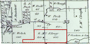
This is an 1872 map, the earliest map found showing the exact area (owned by Robert McElroy in 1872).
(click on map to enlarge)
|