![]()
Iowa: The Rivers of Her Valleys The Yellow River |
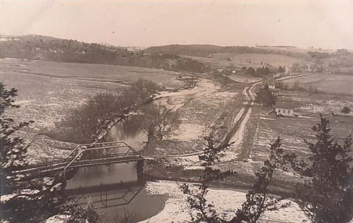
Birdseye view of the Yellow River, ca 1909 - photo postcard
THE YELLOW RIVER
LONG in history but short in miles is the Yellow River, a stream well known to the white man before the signing of the Declaration of Independence. A Connecticut Yankee, Jonathan Carver, was probably the first to call attention to this picturesque stream by its present name. Carver arrived at Prairie du Chien in October, 1766, bent on exploring the interior parts of North America for the British Crown. After a few days sojourn at the "Dog Plains" (Prairie du Chien), Carver set out up the Mississippi with his French companions. "A little farther to the west, on the contrary side", he wrote afterwards in his book of travels, "a small river falls into the Mississippi, which the French call Le Jaun Riviere, or the Yellow River. Here the traders who had accompanied me hitherto, took up their residence for the winter. I then bought a canoe, and with two servants, one a French Canadian and the other a Mohawk of Canada, on the 19th proceeded up the Mississippi."
In the years that followed, many noted travelers called attention to Carver's Yellow River. Bound for the headwaters of the Mississippi in 1805, Lieutenant Zebulon M. Pike found the "Yellow river, of about 20 yards wide, bearing from the Mississippi nearly due West. Twelve years later, in 1817, when Major Stephen H. Long made a voyage in a six-oared skiff to the Falls of St. Anthony, he "Passed Yellow River on our left, about two miles" above Fort Crawford. He reported that it was "navigable for pirogues, in time of high water, about fifty miles from its mouth." Giacomo Beltrami and William H. Keating passed the mouth of the Yellow River in 1823. Both men mentioned Paint Rock, just above the mouth of the Yellow River. Moreover, the map accompanying Keating's narrative of Major Stephen H. Long's expedition of that year accurately locates the Yellow River.
This was not the first time the Yellow River had been charted. Jonathan Carver showed the "Yellow River" on his map of 1778. Victor Collot recorded it in 1796 and Samuel Lewis included it on his map of Louisiana in 1804. Geographical information was of course vague, since details were often supplied by imagination. Perhaps the frequency of historical reference to the Yellow River exaggerated its importance in Lewis's opinion for he indicated its source in a lake somewhere in the vicinity of present-day Marshalltown. The river as Lewis represented it was virtually as long as the Wisconsin River and much longer than the Iowa River.
Zebulon M. Pike's map of the Mississippi River published in 1810 accurately located the Yellow River. It was shown to be emptying into the Mississippi from the west a short distance above the mouth of the Wisconsin. The errors contained in the map of 1804 were corrected and the river was reduced to its proper relative size. Henceforth the Yellow River was invariably included on maps of the upper Mississippi. Lieutenant Albert M. Lea, for example, in publishing his Notes on Wisconsin Territory, with a Map, in 1836, did not fail to record the famous little stream on his map.
Although the Yellow River was well known by name, its physical characteristics remained undiscovered for many years. Though the great route of exploration along the Mississippi passed its very door, little accurate information was obtained about this precipitous inland stream. Indeed, had the first explorers ascended the river any distance it is likely the Yellow River would have received a different name, for only the water at the mouth of the river possessed a muddy, yellow appearance. Few streams have clearer water than the Yellow River.
The Yellow River rises among the "numberless terminal twigs" that spread out "fan-like" in southeastern Winneshiek County. The main branch of the river extends westward to within almost a stone's throw of Ossian, which occupies an elevation of 1271 feet above sea level on the Cresco-Calmar ridge. Despite its small size (the stream is only forty-four miles long and has a basin of only 235 square miles) the Yellow River is an exceptionally beautiful stream. The canyon is narrow and steep-sided, with an exceedingly tortuous gorge. Throughout the greater part of its course the river flows over a rocky bed covered in some places by thin layers of clay deposited by the annual spring freshets.
A distinctive characteristic of the Yellow River is its precipitate descent, the incline in one section being 27.6 feet per mile, three times as great as that of the Upper Iowa. Only Paint Creek, Village Creek, and the Little Maquoketa exceed the Yellow River in the rapidity of their flight to the Father of Waters. It would take strong arms and stout hearts, Stephen H. Long's journal to the contrary notwithstanding, to ascend the swirling Yellow River in flood times.
Throughout its course the Yellow River is joined by numerous minor streams. In fact, geologists assert that the Yellow River is the best example of the "widely branching dendritic type" of waterway, a form generally assumed by streams in unglaciated or geologically old regions. According to W J McGee such waterways have a relatively broad basin, and their tributaries are numerous, widely branching, and so uniformly distributed that their entire basins are effectively drained. Eleven streams in northeastern Iowa — Village Creek, Paint Creek, Yellow River, Bloody Run, Snymagil, Buck Creek, Little Maquoketa, Catfish Creek, Tete de Mort, the North Fork of the Maquoketa, and Elk Creek — fall wholly into this class.
Because of its narrow bed and swift descent the Yellow River was recognized by early settlers as an ideal stream to harness for waterpower. Mills were located at many points. As a matter of fact the first water mill in Iowa was built on the Yellow River in 1831 by troops from Fort Crawford. This mill was located about three miles above the mouth of the river and was operated at first by Lieutenant Jefferson Davis. For a number of years this sawmill fairly hummed with activity as oak timbers were cut from the woods nearby and pine logs were floated down the Mississippi from the Chippewa to be converted into lumber for the second Fort Crawford. A few years later, its work done, the mill finally burned to the water's edge, like an ill-fated Mississippi steamboat. Posterity has appropriately named this mill on Yellow River the Jeff Davis Mill, in honor of the young soldier who was destined to become the President of the Confederate States of America.
The Yellow River is also noted for the Winnebago Mission School which stood a few miles up the river from Jefferson Davis's sawmill. Opened in the spring of 1835 by Indian Agent Joseph M. Street, the school on Yellow River was in charge of the Reverend David Lowry, a Presbyterian minister appointed superintendent of the school by President Andrew Jackson. It was a good, plain structure, built of stone, a veritable landmark in a sparsely settled valley. The peak of enrollment was reached in 1839, when seventy-nine Indian boys and girls attended classes. In the following year some visitors from Prairie du Chien expressed astonishment at the orderly and effective manner in which the school was conducted. But on October 1, 1840, Lowry received orders to sell the building and reestablish the school on the Turkey River in the Neutral Ground.
The earliest settlements in Allamakee County were made in the valley of the Yellow River. The land on which the old Winnebago Indian Mission stood was sold to John Linton in 1842. Not long afterward, Thomas C. Linton, the organizing sheriff of Allamakee County, acquired this tract from his brother when the latter decided to practice medicine. On April 4, 1844, the Clayton County commissioners established the "Yellow River precinct" and in the following year the first election in Allamakee County was held in "the house of Thomas C. Linton, on Yellow River". During the fifties such towns as Nezeka, Ion, Buckland, Volney, Smithfield, and Manchester — none of which now exist as towns — were located and platted on the banks of the Yellow River. In 1859 a traveler described Volney as sitting "squat like a toad" on the "north shore". Optimism reached its apex on October 10, 1856, when the Mississippi and South Pass Railroad Company was incorporated for the purpose of constructing a railroad from the Mississippi "at or near the Yellow river" through the Territories of Minnesota and Nebraska to South Pass in western Wyoming, over a thousand miles away. No railroad, indeed no primary highway, has ever been built up this winding valley.
They were brave days when those early settlers pioneered in the valley of the Yellow River a century ago. Now the shimmering stream is known as the "River of Lost Mills". Gone are the turning water wheels that made the valley one of the "liveliest industrial centers west of the Mississippi". Gone too are the paper towns whose progenitors once dreamed of stately buildings gracing flourishing metropolitan centers. The entire population of the four southern Allamakee County townships through which the river flows is less than that of Waukon at the headwaters of Paint Creek. Not a single town located on the Yellow River has a population sufficient to be recorded as urban (2500 or more) in the Federal census. Only the river itself flows on — just as it did when Jonathan Carver visited the region one hundred and seventy-five years ago.~*~*~
~text source: Iowa: The Rivers of Her Valleys, by William John Petersen, 1941
~contributed by Cindy Bray Lovell
~photo source: ca1909 birdseye photo postcard of the Yellow River
~contributed by S. Ferrall