|
The first counties in the present state of Iowa were estabhshed before there
was any state or even territory of that name. While the history of the formation
of Webster county does not extend back this far, yet in order to get a clear
understanding of the history of how Webster county came to be, it is necessary
to go back to this early time.
In the "Ordinance for the Government of the Territory of the United States
northwest of the river Ohio," the governor of the territory was given power to
lav out into counties and townships those parts of the districts to which the Indian
titles had been extinguished. This right was also given them under the acts of
congress which established the territories of Indiana and Michigan. The last
use of this authority was by Governor Cass in his proclamation issued September
10, 1822. The next counties established in the territory were created in
1826 and 1829 by acts of the legislative council.
Upon the admission of Missouri to the Union as a state in 1821 the country
included within the present bounds of Iowa was left without any established
local government. Following the Black Hawk war a treaty was made on September
21, 1832, with the Sac and Fox Indians by the terms of which there was
ceded to the United States government a strip of territory in eastern Iowa. This
district was vacated by the Indians and officially thrown open to settlement June
I, 1833. Immediately a large number of prospective settlers entered the new
purchase ; indeed, many had not waited for the date of the official opening.
This new population found itself "beyond the pale of constitutional government.''
Some violence occurred. Out of the violence grew a petition to congress
asking for the protection of the federal laws. The result was an act of
congress approved on June 28, 1834, by which the area of the present state of
Iowa was, "for the purpose of temporary government, attached to, and made a
part of. the territory of Michigan."
71
72
September i, 1834, the legislative council met in extra session at Detroit,
where it had been convened by proclamation of the governor. In the message,
which the governor sent the council on the second day of the session, the attention
of the council was called to the needs of the people west of the Mississippi, in the
territory recently attached to Michigan. The reference was clearly to the inhabitants
of the Black Hawk Purchase, since no other territory west of the Mississippi
had, as yet, been thrown open to settlement. In this district, the governor
recommended the establishment of counties, townships, and courts. In
response to the recommendation of the governor, the legislative council passed
an act entitled, "An act tO' lay off and organize c'ounties west of the Mississippi
river." This act which constitutes the first step in the formation of counties in
the Iowa country, was approved on September 6, 1834, to take effect on the
first day of October of the same year. It applied only to that part of the present
state of Iowa, "to which the Indian title had been extinguished." This refers
to the "Iowa District," or the "Black. Hawk Purchase," or "Scott's Purchase,"
as the Sac and Fox cession of September 21, 1832, was variously called. This
act divided the district into two counties Dubuque and Demoine. W^ith the
admission of part of the territory of Michigan to the Union as a state, the
remainder was by act of congress, approved on April 20, 1836, erected into the
new Territory of Wisconsin. The area of the present state of Iowa, with its
two counties, was included in the new jurisdiction. The first session of the
legislature of the Territory of Wisconsin met at Belmont on October 25, 1836.
In the following December the legislature passed a law entitled "An act dividing
the county of Des Moines, into several new counties." This act was approved
December 7, 1836, and went into force immediately. This created out of the
former county of Demoine seven new counties.
By the terms of a treaty made on October 21, 1837, the Sac and Fox Indians
made a new cession of Iowa lands to the United States government. The territory
ceded comprised a triangular strip of 1,500,000 acres lying immediately
west of .the Black Hawk Purchase.
During the second annual session of the legislative assembly of the Territoryof
Wisconsin, which convened at Burlington in the county of Des Moines, on
November 6, 1837, two very important acts were passed relative to the formation
of counties in Iowa. The first of these laws, which was approved on December
21, 1837, subdivided the former county of Dubuque into a number of new
counties. The boundaries of these counties were very irregular and not definitely
defined. Even the wording of the act, which created the counties, was capable
of different constructions. Benton county extended entirely across the state
of Iowa, while Buchanan did the same and also reached into South Dakota.
Fayette county extended so far north and west that it included all of Wisconsin
Territory west of the Mississippi river and north of the southern part of Clayton
county, exclusive of the area of Clayton county. It included most of the
territory of the two Dakotas and Minnesota together with a part of Iowa. Its
area was upward of 140,000 square miles. Included in its area was the present
county of Webster. Subsequent sessions of the legislature passed various acts,
seeking to more clearly define the boundaries of existing counties.
By an act of congress approved on June 12. 1838, the original Territory of
73
Wisconsin was divided. The part west of the Mississippi river, and west of a
Hne drawn due north from the source of the Mississippi, received the name of
the Territory of Iowa. It included not only the area of the present state of Iowa,
but also that of the western part of Minnesota and of the eastern part of the
two Dakotas. Its area was about three times that of the present state of Iowa.
The Organic Act of the Territory of Iowa was to be in force from and after
July 3, 1838. From this date the territory continued in existence until December
28, 1846, when the state of Iowa was finally admitted into the Union.
The first session of the legislature of the Territory of Iowa passed several
acts in January, 1839, relative to counties. Some of these dealt with the organ-_-
ization of counties, others relocated seats of justice, provided for the sale of
public lands, and similar matters. Four acts created new counties or altered
the boundaries of counties already created.
After the minor acts of January, 1839, no more new counties were created
in Iowa for four years. In the meantime the Sac and Fox Indians had ceded
to the United States a vast region in the central aiid south central part of the
state of Iowa. Under various acts of the legislature, this territory was divided
into counties. These acts also sought to define the boundaries of existing counties.
The first act of the federal congress authorizing the admission of Iowa into
the Union was approved on March 3, 1845. Then followed nearly two years
spent in the adoption of a constitution and in the adjustment of boundaries. The
act which finally admitted the state was not passed and approved until December
28, 1846.
At this time Iowa contained forty-four counties covering a little less than
one-half of the state. On January 15, 185 1. the general assembly of the state
of Iowa passed the most important act in the whole history of the formation
of counties in Iowa. At least it was the most comprehensive and created the
largest number of counties. By this measure fifty counties were established
embracing fully one-half of the state. Among the counties created by this act
were the counties, of Risley and Yell, the former constituting the present county
of Hamilton, and the latter the present county of Webster, with the exception
of the northern tier of four townships. These townships w-ere included in the
confines of the county of Humboldt. The name Yell was in honor of Colonel
Yell, who was killed in the Mexican war. While the majority of the counties
as established under this act remained permanent, sixteen of them were changed
by subsequent legislation. Four of them. Yell, Humboldt and Bancroft were
subsequently blotted out. Before this occurred the name Risley had been changed
to Webster; and Humboldt, after having been blotted out, was restored.
On the whole, the law^ of January 15, 1851, is noticeable for the superior
manner in which the boundaries of counties are defined. Compared with earlier
laws its language is clear and simple. It is comparatively free from errors.
This act fully completed the subdivision of the state of Iowa into counties. Subseqvient
acts only changed the names, or readjusted boundaries already established.
The fourth general assembly of the state of Iowa passed a law, which was
approved January 12, 1853, and which changed the name of Risley to Webster;
and attached the county for revenue and election purposes to Boone county. On
74
January 22, 1853, the same assembly passed an act entitled "An act to create the
county of Webster." The act of January 12, 1853, which changed the name
from Risley to Webster was to go into effect upon publication in certain papers.
A certification signed by the secretary of state accompanies the law to the effect
that the act was published in the required newspapers on January 22, 1853. This
date is the same as that of the approval of the new law to "create Webster
county by uniting Risley and Yell into one new county to be called Webster."
The latter act was "to take effect from and after its publication in the Iowa
Star ; Provided the state shall incur no expense for such publications." No accompanying
note tells when the act was so published. It was usual in such cases
for a few days to elapse between the approval of an act and its publication.
The fifth general assembly passed two laws affecting county boundaries.
One of these laws was passed by the legislature January 21, 1855 and was
approved on the same day. It bore the title of "An act to extend the boundaries
of Kossuth county, and to locate the seat of justice thereof ;" but this title was
not adequate to the contents of the measure. By the terms of this act the counties
of Bancroft and Humboldt were blotted out. Bancroft and the northern half
of Humboldt were,added to Kossuth; while the southern half of Humboldt was
added to the already overlarge county of Webster, making it the largest county
in the state, having an area of forty townships or 921,600 acres. Thus the
boundaries of Kossuth and Webster were enlarged. But these boundaries were
not to be permanent as will be seen later.
The sixth general assembly, like the fifth, passed two laws, bearing upon the
subject of this chapter. The first of these was approved on December 22, 1856,
and went into force on January 8, 1857. This act created a new county, to be
called Hamilton, out of that part of \Vebster county which lay east of range
27 west. In size it was four townships square, having exactly the same boundaries
as the former county of Risley. Its boundaries, as thus established, have
remained permanent.
The other act passed at this session was approved on January 28, 1857, and
went into force on February 26. It created the county of Humboldt between
Wright and Pocahontas. To do this eight townships were taken from Kossuth
and four from Webster county. The new Humboldt, as its boundaries were
defined in the law, was four townships smaller than its predecessor of the same
name. It was also smaller than Wright and Pocahontas counties, its neighbors
on the east and west.
During the next session of the legislature an act explanatory of the one
under discussion was passed. In a preamble of two paragraphs it was claimed
that the act of January 28, 1857, had originally created Humboldt county of a
larger size, that is, four townships square. The preamble claimed, further, that
a mistake had been made when the act was printed in the public laws, whereby
township 90 had been omitted, and also that the original of the bill had been
lost. This being the situation the legislature passed a new act construing that
of January 28, 1857, in such a way as to include township 90, ranges 27, 28,
29, and 30 in Humboldt county. The act even went further and defined the
boundaries of the county anew in such a way as clearly to include the territory in
dispute.
75
Between the passage of the two laws just discussed the present constitution
of Iowa was declared in force. It contained a provision to the effect that future
laws altering county boundaries should be submitted to a vote of the people of
the counties concerned and must be approved by them before going into effect.
The amendatory law of IMarch ii, 1858, had not been submitted to the people for
ratification. Consequently the supreme court of the state, by a decision handed
down on December 4, i860, in the case of Buncombe vs. Prindle, 12 Iowa i,
which had been appealed from the district court of Webster county, declared the
act of March 11, 1858, unconstitutional.
The case which was a test case, was based upon a suit instituted in Webster
county, upon a promissory note for one hundred and twenty-five dollars, dated
October, 1858, and payable at thirty days. The defendant set out by way of
answer, that he resided in township 90, range 28, west of the 5th P. M., which
township was situated within the boundaries of Humboldt county, as he claimed
would more fully appear by an act approved January 28, 1857, entitled, "An Act
to create the County of Humboldt;" and "An Act explanatory of the act, entitled,
'An Act to create the County of Humboldt;" approved March 11, 1858, which
act set forth, that in the first named act, townships 90, 91, 92 and 93 in ranges
2^], 28, 29 and 30, were erected into the county of Humboldt, according to the
language of the original bill as passed, but that in the printing and publication
of this act, township 90, in the ranges of 27 to 30 inclusive, were omitted. The
defendant claimed, that this omission was afterwards supplied by the explanatory
act aforesaid (of March 11, 1858), and, therefore, not having been sued
in his own proper county, he demanded a change of venue to Humboldt county.
The plaintiff', in his replication, controverted the afifirmative statements in the
answer, proffered a certified copy of the original manuscript act, approved January
28, 1857, as found enrolled in the secretary's offfce, and averred that there
was in fact no conflict or discrepancy between the original manuscript of the
act and the same act as published. The plaintiff insisted that the facts set out
in the preamble of the supposed explanatory act of 1858 were untrue. He alleged,
that if by this last act the defendant insisted that township 90, of the ranges
aforesaid, had been made a part of Humboldt county, that still said law was
inoperative, and could have no binding effect, until it had been submitted to the
people of Webster and Humboldt counties, to be voted upon at a general election,
and approved by a majority of the votes of each county. Such vote, the plaintiff
claimed, as a matter of fact had never been taken.
To this replication the defendant interposed a demurrer which was overruled
by the court. Judgment was then rendered for the plaintiff on the note, and the
defendant appealed.
The appellant was represented in court by Messrs. Kasson, Cole and Garaghty,
while the appellee was represented by Alessrs. John F. Buncombe and G. H.
Bassett. The decision, which afffrmed that of the district court, was given by
Chief Justice Lowe. The court held, that this act did not relate back to the act
of which it was amendatory ; and as an independent act it was invalid because it
had never been submitted to a vote of the people of the comities concerned. In
the closing words of his opinion the court says, "We are compelled to conclude
that township 90, in ranges 27 to 30, west of the 5th principal meridian, is still
76
in and forms a part of Webster county. Of course we can pay no attention to
conjectural surmises and vague suspicions, which have been made and entertained
in relation to some unfairness which may have been practiced in the final passage
of the act of 1857, creating the county of Humboldt. If such was the case, no
evidence of the fact has been presented to us. We have had to deal with the
case as made ; and the record as spread before us."
The result of this decision was to reduce Humboldt county in size to the
dimensions which the act of January 28, 1857, had given it, whether as approved
this act expressed the real intention of its framers or not. The county, however,
should be considered as containing sixteen townships from March 11, 1858, the
date of the approval of the amendatory act, until the same was declared unconstitutional
on December 4, i860.
It may seem strange to class the customs of the pioneers among the early
laws of Iowa; but as Dr. B. F. Shambaugh in his book, "History of the Constitutions
of Iowa," says, "constitutions are not made in a single day, but have
evolved by slow degrees from customs, so the rules and regulations .of the
claim clubs of early Iowa may be said to be the beginning of its civil government."
The early settlers of Iowa were not a lawless body of men. The customs
governing the holding of claims were well and honestly ol)served. These
customs codified into resolutions and by-laws, became the first written laws of
the pioneers of Iowa. Squatter constitutions they were, but they were law.
These claim clubs were the product of necessity. By cession and purchase the
United States held legal title to all lands in Iowa, but the Indians occupied the
land, and their right to possession was not denied, until extinguished by formal
agreement. Until this was done, legal settlement could not be made by the white
citizen. United States statutes at large prohibited settlement upon lands to which
the Indian title had not yet been extinguished, and upon lands which were not
surveyed. But the tide of immigration could not be stopped. The pioneers
pressed ever westward. Claims were staked. Homes were built and farms
began. All of these claims were beyond the pale of constitutional law. Yet
10,000 of them were in Iowa before the public surveys began. In law these
squatters were trespassers,—in fact they were honest farmers. It was to meet
these conditions and to protect what they termed their rights to their claims
that the early settlers formed land clubs or claim associations.
The claim club of Fort Dodge was organized and active after Iowa became
a state. The records of this association and that of the claim association of
Johnson county are the only complete records in existence.
The manuscript records of the claim club of Fort Dodge, discovered several
years ago among the papers of Governor Carpenter, are now carefully
preserved by the historical department at Des Moines. From these records
it appears, that the first meeting of the claim club of Fort Dodge was held on
the 22(1 of July, 1854. William R. Miller was chosen chairman, and W. A.
Young, secretary. According to the minutes of the meeting, the "citizens met
pursuant to a call for the purpose of forming a claim law." At this meeting a
committee, consisting of Volney Knight and W. A. Young, was chosen to draft
a "code of laws," and to report at the next meeting. After some discussion the
following motions were passed:
77
"First, that 320 acres shall constitute a claim. Second, a claim may be held
one month by sticking stakes and after that 10 dollars monthly improvements
is necessary in order to hold a claim. Also that a cabin 16x16 feet, shingled
and enclosed so as to live in it, is valued at $30." The meeting then adjourned
to meet at Alajor Williams store, Monday, July 24, at 7.00 P. M. At the
meeting the following by-laws and resolutions were adopted :
"Whereas the land in this vicinity is not in market and may not be soon.
We the undersigned claimants deem it necessary in order to secure our lands
to form ourselves into a club for the purpose of assisting each other in holding
claims, do, hereby form and adopt the following by-laws :
Resolved first. That every person that is an actual "claimant is entitled to
hold 320 acres of land until such time as it comes into market.
Resolved second. That any person who lives on their claim, or is continually
improving the same is an actual claimant.
Resolved third. That staking out a claim and entering the same on our
claim book shall hold for one month.
Resolved fourth. That $10 monthly shall hold a claim thereafter.
Resolved fifth. That no man's claim is valid unless he is an actual settler
here, or, has a family and has gone after them, in which case he can have one
month to go and back.
Resolved sixth. That any person not living up to the requirements of these
laws shall forfeit their claim, and, any actual settler who has no claim may
settle on the same.
Resolved seventh. That any person going on another's claim that is valid,
shall be visited by a commission of three from our club and informed of ihe
facts and if such person persist in their pursuits regardless of the commission
or claimant they shall be put off the claim by this club.
Resolved eighth. That the boundaries of these laws shall be 12 miles each
way from this place.
Resolved ninth. That this club shall hold its meetings at least once in eacli
month.
Resolved tenth. That the officers of this club shall consist of a chairman
and secretary.
Resolved eleventh. That the duty of the chairman is to call to order, put
all questions, give the casting vote when there is a tie, etc., etc.
Resolved twelfth. That the duty of the secretary is to keep the minutes
of the meetings and read the same at the opening of each meeting and have the
book and papers in his charge.
Resolved thirteenth. That any or all of the by-laws may be altered or
abolished by a majority vote at a regular meeting."
On the offense of '"claim-jumping" the records of the Fort Dodge club contain
this suggestive entry : "On motion of Wm. R. Miller that if any member
of this club finds his or any of his friends clames has been jumpt that they
inform this club of the fact and that this club forthwith put them off of said
claim without trobling the Sivel law."
These squatter constitutions made it possible for the settlers to establish:
78
homes without immediate payment. They gave color of title, and thus made
possible and protected the settlers in their improvements. They gave peaceful
possession against the speculator and claim jumper, and even against the government
itself. They fostered and established on the frontier, justice, equality
and democracy. The prominence which they gave to the homestead and its
rights probably suggested our present homestead exemption laws. On the
rude frontier, where lawlessness was the tendency, they upheld the rule of law.
The law of these claim clubs was carried by settlers, from Iowa to the new
state of Nebraska and formed the basis of the first law there.
The claim clubs were mere makeshifts of government, the outgrowth of conditions
which made them necessary. However they created a desire and showed
the necessity of codified law and established government. So in March, 1853,
the citizens of what was then Webster county petitioned Honorable Samuel
B. ]\IcCall, county judge of Boone county, to which county Webster was at
that time attached for revenue and election purposes, to order an election of
county officers. The prayer of the petitioners was granted, and an order issued
for an election to be held on April 4, 1853. At this election an aggregate of
sixty-three votes were cast. Returns were made to Judge McCall, who on
April 9, 1853, issued certificates to the ten officers elect, namely: a county judge,
a clerk of the district court, a prosecuting attorney, a recorder, a sheriff, a
coroner, a school fund commissioner, a surveyor and a drainage commissioner.
Since the first election, some of the offices have been abolished, the names
of others have been changed, and a number of new ones have been created. At
the present time there are, including the board of five supervisors, thirteen
elective officers. The other county officers are : auditor, clerk of court, treasurer,
recorder, sheriff, superintendent of schools, coroner and county attorney.
The office of county judge existed from 1853 ^o 1868, in which year the duties
of the office were assumed by the board of supervisors, established i860. The
last drainage commissioner elected was in 1867. The county auditor's office, a
sort of overflow from the other offices, was established in 1868. The first
incumbent was Wilson Lumpkin, who performed the duties of the office in
connection with his duties as clerk. The office of school fund commissioner
was abolished in 1857, John Tolman being the last one to hold that position.
In 1859, the office of superintendent of common schools was established and
the office was filled by S. B. Olney, who was elected at the election held the
first ^Monday in April, 1858. Until the year 1865, the duties of treasurer were
performed by the recorder. In that year the two offices were separated and
Jared Fuller was elected the first treasurer. The county attorney was at first
known as prosecuting attorney. The records show the existence of such an
office until the year 1856, when Charles B. Richards was elected. Then until
1886 there was no regularly elected attorney. In that year, by an amendment
to the state constitution, the name was changed to county attorney, and Albert
E. Clark was'elected to the office. In 1873, the journal of the board of supervisors,
shows that John F. Duncombe was hired by that body as attorney of
Webster county for a term of two years. The thirty-fourth general assembly
in 191 1, abolished the office of surveyor, the act taking eft"ect July 4, 191 1. The
last person to fill this office was G. P. Smith. Under the act, abolishing the
79
office of surveyor, the board of supervisors is given authority, if they desire,
to hire an officer to be known as county engineer.
Soon after the organization of the county the judge of the fifth judicial
district, of which Webster county then formed a part, appointed three commissioners
to select a site and locate a county seat. The commission selected
the southwest quarter of section 6, township 87, range 26. Here a town was
laid out and named Homer. But the villagers of Fort Dodge were aggressive.
Under the leadership of John F. Buncombe and others they began a fight to
secure the county seat. On Alarch 3, 1856, John F. Buncombe, Walter C. Willson
and others to the number of 357, presented to the court a petition asking
for an election to be held on the first Alonday in April, 1856, to vote on the
question of the removal of the county seat from Homer to Fort Bodge, While
they lived on opposite sides of the county, yet the interests of these two men
were mutual. Air. Buncombe was boosting for Fort Bodge. Mr. Willson, planning
for the future, had in mind a division of the county, and the creating of
a new county out of the eastern part, with another county seat town. \\'ith the
petition was also filed a remonstrance signed by George Gregory and 347 others.
The court granted the petition, and the election was held April 7, 1856. The
canvass of the votes resulted in favor of Fort Bodge by a vote of 407 as against
264 for Homer. Soon after the records were removed to Fort Bodge. The
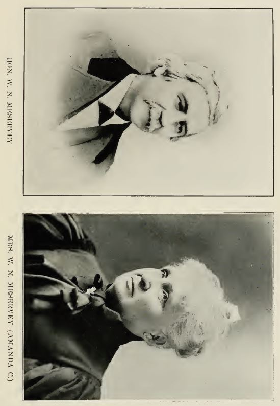
removal of the county seat brought to Fort Bodge, as residents, several county
officers, among them Hon. William X. Meservey, who later played an important
part in the making of the new county seat town.
By an act of the fifth general assembly, approved January 24, 1855, the
unorganized counties of Wright, Kossuth, Humboldt, Winnebago, Palto Alto.
Emmet, Pocahontas and Hancock were attached to Webster county for election,
judicial and revenue purposes. These counties were all later organized by the
county judge of Webster.
There is an interesting incident in connection with the organization of Humboldt
county. About the first day of April, 1857, Honorable Samuel Rees, then
county judge of Webster county, deputized Henry A. Cramer, at that time a
resident of Humboldt county, as deputy sheriff and gave him a warrant for the
holding of an election in the county on the first Monday in April, with orders
to serve the same. Cramer took his warrant and went to Humboldt county ;
but found the homes of the settlers deserted, they having fled to Fort Dodge
from fear of the Indians, who were at that time reported as being on their way
down the Des Moines river. Cramer found food cooked and warm on the
stoves. He helped himself to the eatables and returned his warrant unserved.
Judge Rees subsequently issued another warrant for an election to be held the
first Monday in August, 1857. At this election Major Jonathan Hutchinson,
who afterwards became treasurer of Webster county, was elected county judge.
Webster county contains twenty congressional townships, each containing
thirty-six sections of land. It has therefore an area of 720 square miles or
460,800 acres. As first organized in 1853 it contained thirty-two congressional
townships. Buring the years 1855 and 1856, this was increased to forty. Upon
the organization of Hamilton and Humboldt counties in 1857, Webster county
was reduced to its present size.
80
Webster county is divided into twenty-four civil townships : Badger, Burnside,
Clay, Colfax, Cooper, Dayton, Deer Creek, Douglas, Elkhorn, Fulton,
Cowrie, Hardin, Jackson, Johnson, Lost Grove, Newark, Otho, Pleasant Valley,
Roland, Sumner, Wahkonsa, Washington, Webster and Yell.
Washington township was the first township organized in the county and
embraced all the territory now contained in Webster and Hamilton counties.
In August, 1853, County Judge William Pierce, established two new townships,
Hardin and Webster, and left Washington township all the territory
north of township 87 in the county. In 1857, its boundaries were again reduced,
when Wahkonsa township was established. These boundaries, with a slight
change made in 1870, are the boundaries Washington now contains, to wit :
all of township 88, range 27, and sections i, 12, 13, 24, 25, 26, 35 and 36, of
township 88, range 28, east of the Des Moines river.
Hardin township, as organized in 1853, contained all the territory in township
86 of what was then Webster county. By the organization of Yell and
Clear Lake townships in 1856, its boundaries were reduced to township 86,
ranges 27, 26 and 25 east of the Des Moines river in what was then Webster
county. When Hamilton county was organized, Hardin was given its present;
boundaries, being all of township 86, range 27, east of the Des Moines river.
Webster township as organized in 1853 embraced all the territory in township
87, in what was then Webster county. By the organization of Yell and
Clear Lake townships, its boundaries were reduced to that part of township 87,
ranges 25, 26 and 27, on the east side of the Des Moines river. After the
division of the counties in 1857 the county judge ordered the township reorganized
so as to contain only that part of township 87, range 27.
In 1856, six new townships were established namely: Wahkonsa, Yell, Clear
Lake, Boon, Cass and Humboldt. Wahkonsa and Yell w'ere in what is now
Webster county while Clear Lake, Boon and Cass were in what is now Hamilton.
Humboldt township included the northern tier of townships of the present
county of Webster, and the southern tier of townships of the present count}'
of Humboldt.
Wahkonsa township, as first organized, had the following boundaries :—
commencing at the northwest corner of said county, thence east on said county
line to the range line between ranges 27 and 26, thence south to the correction
line, thence south to the northeast corner of section 12, township 88, range 27,
thence west to the Des Moines river, thence down said river to the south line
of section 8, thence west to county line, thence north on said line to place of
beginning. These boundaries were changed March 24, 1857 and the township
then embraced all east of the Des MIoines river and north of the line between
sections 12 and 13, 11 and 14. 10 and 15, 9 and 16, 8 and 17, 7 and 18, township
88, range 27. Badger township was taken from Wahkonsa township in
1865; and, in 1872, its boundaries were reduced to township 89 and range 28.
Wahkonsa now embraces only the city limits of Fort Dodge.
Yell township as originally organized had the following boundaries : commencing
at the northwest corner of section one, township 87, range 28, thence
west to the county line, thence sotith on said line to the Boone county line, thence
east on said line between Webster and Boone countv to the Des Moines river,
81
thence along that as a Hne to place of l^eginning. In 1858 it was given its present
boundaries. They embrace all of township 87, range 27, west of the Des
Moines river. Clear Lake township, as organized in 1856, embraced all of
townships 86, 87, 88 and 89 in ranges 24 and 23, of what is now Hamilton
county. Boon township was organized ]^Iarch 3, 1856, and included township
88 and 89, ranges 26 and 25, of what is now Hamilton county. On March 15,
this township was divided and township 89, ranges 26 and 25, was called Cass.
Humboldt township as organized ^larch 3, 1856, embraced all of 'townships
90 and 91, in what was then Webster county.
The townships of Otho, Sumner and Douglas were organized in 1857. Otho,
as organized March 2. 1857, contained all of township 88, ranges 28 and 29,
lying west of the Des Moines river. The township of Elkhorn was detached
in 1871, leaving the boundaries of Otho the same as at present, being that part
of township 88, of range 28, on the west side of the Des Moines river. Sumner
township was organized March 2, 1857, and at that time contained all of township
Sj, and west of the Des Moines river. \\'ith the organization of Burnside
township, Sumner was reduced to its present area. By an order of court March
3, 1857, all the territory lying in townships 89 and 90, ranges 29 and 30, on the
west side of the Des Moines river were formed into a township named Douglas.
On September 20, 1859, the court ordered township 90 of ranges 29 and 30
formed into a township, thus leaving Douglas consisting of township 89, ranges
29 and 30. The new township was named Jackson. Again, on November 6,
i860, another township was formed out of Douglas, and township 89, range
30 was constituted Johnson township, leaving Douglas township its present
confines,—all of township 89, range 29, and that part of sections 7, 18, and 19
in township 89, range 28, lying west of the Des Moines river.
Dayton township was organized September 14, 1858. The boundaries as
then fixed were all of township 86, range 28, and that part of township 86,
range 27, lying west of the Des Moines river, except sections 1, 2 and 3.
Jackson township as first organized included all of township 90, ranges 29
and 30. On November 6, i860, the county court ordered township 90, range
29, set off, and a township named Cass formed. The to\\nship Cass, however,
was never organized. October 10, 1865, township 90, range 29, was by order
of court detached from Jackson and named Deer Creek.
Badger township was formed from Wahkonsa by an order of the board of
supervisors, October 10, 1865, and when organized contained township 90.
ranges 2y and 28. Range 27 was, October 14, 1873, taken from Badger and
formed Newark township. The present boundaries of Badger township are
all township 90, range 28, and that part of township 90, range 29, lying west of
the Des Moines river.
Fulton township was organized by an order of the board of supervisors
passed September 11, 1868. It consists of all of township 88, range 30.
Lost Grove township was organized October 18, 1869, and embraces all the
territory of township 86, range 29.
The original boundaries as given to Pleasant Valley, when organized October
II, 1870, were township 89, range 27, and sections 2, 3, 4, 5, 6, 9, 10, 11,
14, 15, 16 and 17, township 88, range 28, and that part of section i, township
82
88, range 29, east of the Des Moines river. November 5, 1872, the board of
supervisors set off township 89, range 27, giving the township its present
boundaries.
The township of Elkhorn was detached from Otho by an order of the
board of supervisors, October 10, 1871. It embraces all of township 88, range 29.
The township of Gowrie was organized October 10, 1871, and included all
of township 86, range 30.
Colfax and Clay were organized November 5, 1872. Colfax includes all
of township 89, range 27. The township of Clay embraces all of township 87,
range 29.
The boundaries given to Newark township as organized October 14, 1873,
were all of township 90, range 27, and these boundaries have remained
unchanged.
Roland township was organized by the order of the board of supervisors
October 12, 1875. Its boundaries are the same as when organized, being all
of township 87, range 30.
Cooper township was organized September 6, 1877. The record of the
board of supervisors, concerning the organization, is as follows : "that the
territory heretofore known as Wahkonsa township be divided as follows : all
that part of said township within the corporate limits of the city of Fort Dodge
to constitute a separate township, and called by the name of Wahkonsa township
; and all that i5art of said township lying outside the corporate limits of
said city of Fort Dodge, to constitute a separate township, to be known and
called by the name of Cooper township, in accordance with a petition now
before the board signed by J. B. Haviland and others."
Burnside township was organized June 16, 1886. At that time Sumner
township was divided into two townships, one embraced the territory within
the corporate limits of Lehigh, and so much of the Independent school district
of Tyson's Mills as was included in said township, outside of said corporation.
This retained the original name of Sumner. The remainder was organized as,
and named Burnside.
At the present time, Webster county is divided into five supervisor districts.
The first supervisor district is composed of Colfax, Newark, Washington,
Webster and Pleasant A alley. The second consists of Badger, Deer Creek,
Douglas, Jackson and Johnson ; the third of Wahkonsa and Cooper ; the fourth
of Gowrie, Dayton, Hardin and Lost Grove and the fifth of Burnside, Elkhorn,
Fulton, Roland, Clay, Otho, vSumner and Yell.
Webster county forms the sixty-second representative district, and with
other counties forms the twenty-seventh senatorial district, the eleventh judicial
district and the tenth congressional districts. The twenty-seventh senatorial district
consists of Webster and Calhoun counties. The eleventh judicial district
consists of the counties of Webster, Boone, Story, Hamilton, Hardin, Franklin
and Wright ; and has three judges, elected at large from the district. The tenth
congressional district consists of fourteen counties : Webster, Calhoun, Hamilton,
Pocahontas, Humboldt, Palo Alto, Kossuth, Hancock, Emmett, Winnebago,
Crawford, Carroll, Greene and Boone.
|