


|
|
Ackworth
Allendale (Ellendale)
Banner
Beech (New Sandyville)
Bellemont (Schonberg)
Bevington
Carlisle
Churchville
Clarkson
Conger
Cool
Cumming
Derrough
Dorrville
Economy (Orilla)
Ellendale (Allendale)
Evansville
Felix (Taunton)
Ford
Fort Gimlet
Fort Plain (Greenbush)
Friends Grove
Genesville
Greenbush (Fort Plain)
Goshen
Hackney's Grove
Hammondsburg
Handsome View
Hartford
Hickory Grove
Higdonville
Hoosier Row
Indianola
Irish Grove
Jefferson (Lacona)
Jefferson Heights
Lacona
Latimer
Lawrenceburg
Liberty Center
Lida (Loretta)
Loretta (Lida)
Lothrop
Lynn
Martensdale (Yaggy)
Mayview
Medford
Medora (Madora)
Milo
Montpelier
Motor (Waveland)
Murdock
New Sandyville (Beech)
New Virginia
Norwalk (Pyra)
Orillia (Economy)
Oswego (Pryor)
Palmyra
Plainville
Pleasant Hill
Prole (Spencerville)
Pryor (Oswego)
Pyra (Norwalk)
Rosemount
Saint Mary's
Sandyville
Schonberg (Bellemont)
Scotch Ridge
Sharon
Spencerville (Prole)
Spring Hill
Summerset
Sutton
Taunton (Felix)
Three Rivers
Union Hill
Waveland (Motor)
Westford
White Oak Point
Wick
Wilmington
Wisconsin
Yaggy (Martensdale)
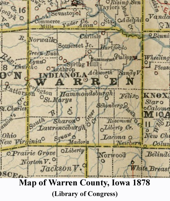
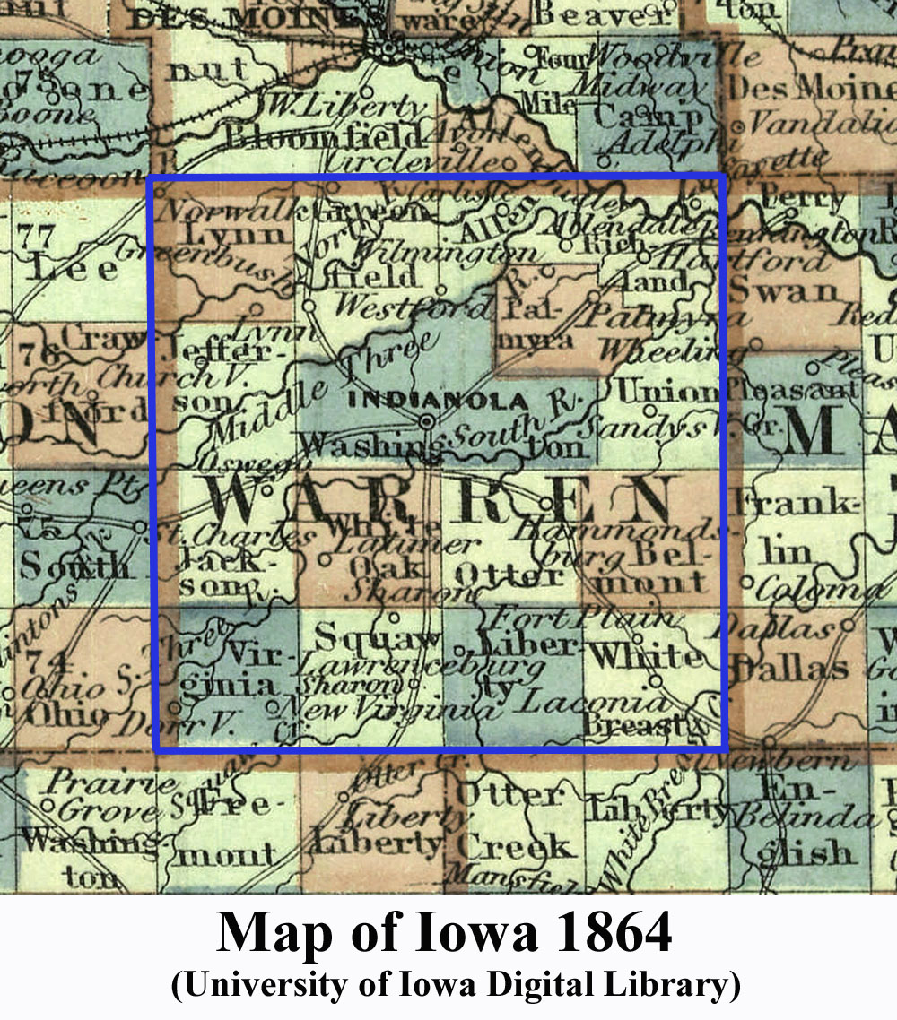
ACKWORTH – Ackworth is located in section 23, Washington Township, along the bottom line of the section, in the middle of the line (see the 1875 map on this site). Ackworth was started by a group of North Carolina Quakers. It was originally known as the South River Settlement. In 1870 the Ackworth Academy was completed. Ackworth was the name of the oldest Friends School in England. Ackworth has Iowa's first zip code number 50001. Early residents include Alex Ginder, David Lair, P. P. Henderson, George Haworth, John Tomlinson, and Mark Moon. The town of Ackworth was incorporated May 9, 1881.
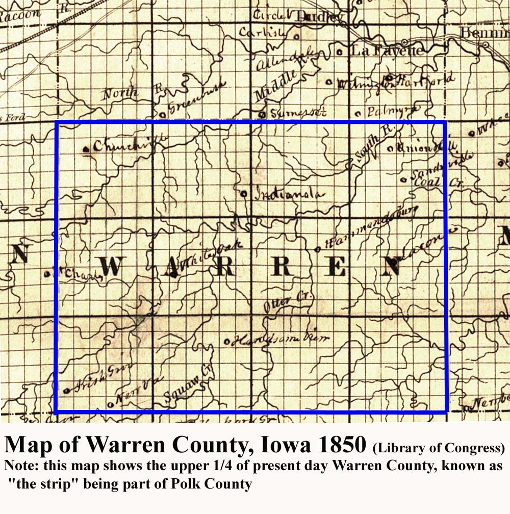
ALLENDALE (Ellendale) – Located in section 12 of Township 77 N, Range 23 W, in what is now Richland Township. It was about 2 miles southeast of Carlisle. See the 1850 Warren County map where it was part of the strip in Polk County. The town's name was originally Ellendale and changed to Allendale.
BANNER – Banner was located near the center of section 7, Virginia Township. Its post offices was established June 25, 1874 and closed fifteen months later on September 17, 1875. The only postmaster was John S. Crawford. I-35 now covers Banner's former location.
BEECH (New Sandyville) – The town of Beech is located in section 23, Union Township. Beech was originally named New Sandyville, but the name was changed to Beech because citizens of nearby Sandyville objected to the name. Beech was named for the railroad surveyor who had laid out the town. The first family to move to the town was Jim and Emma Stone and their two sons, Bliss and Merrill. A 1915 map of Union Township, of Warren County shows this town.
BELLEMONT (SCHONBERG) – Bellemont located in the northwest corner of section 21, Belmont Township (about two miles east of the present town of Milo). Bellemont was established as a post office in 1870. The post office closed in 1871 and the name of the town was changed to Schonberg.
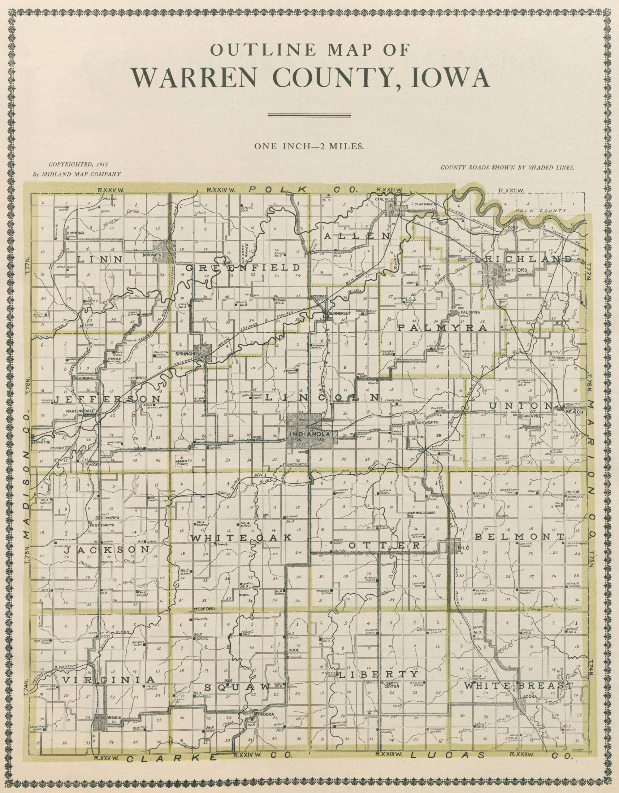
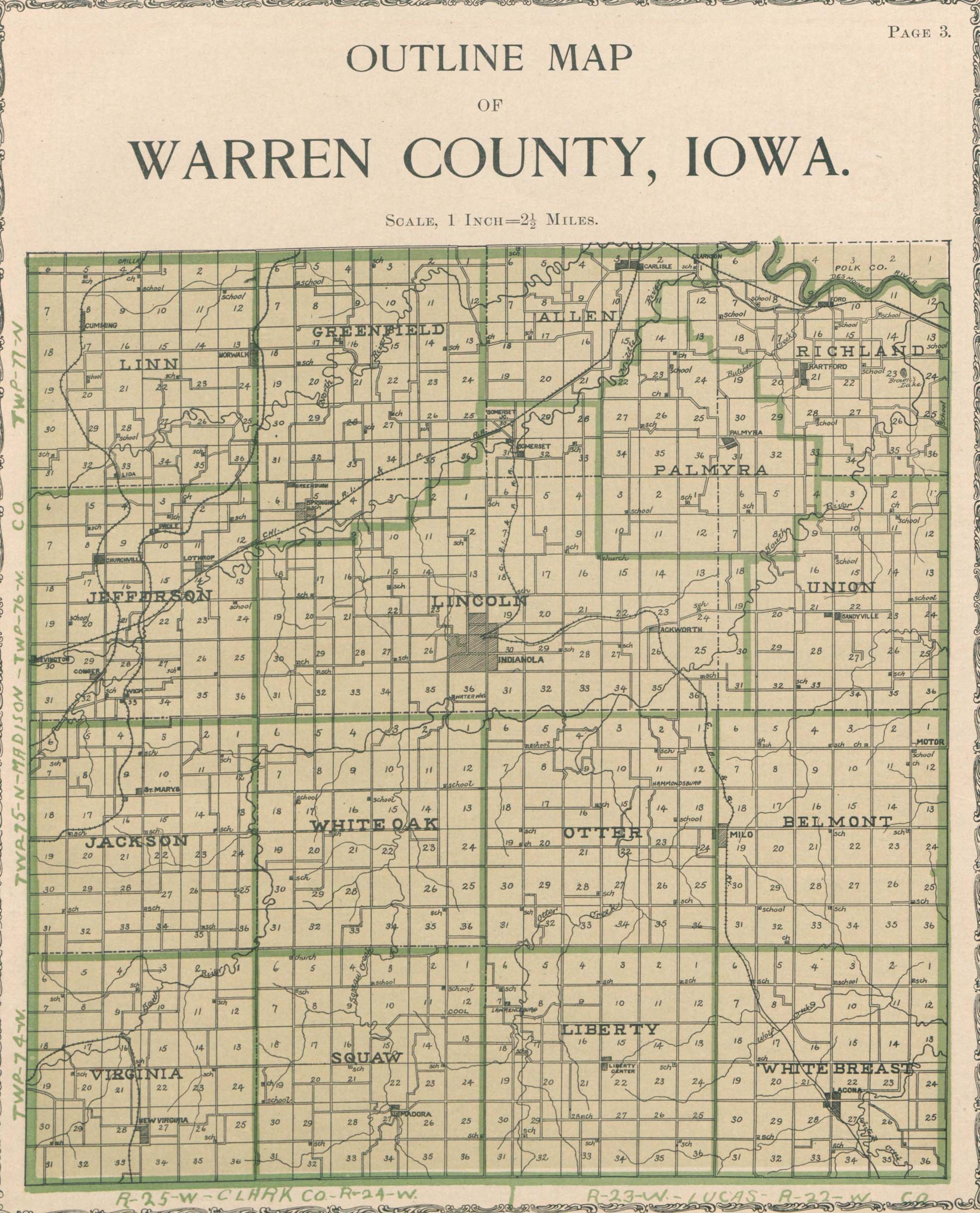
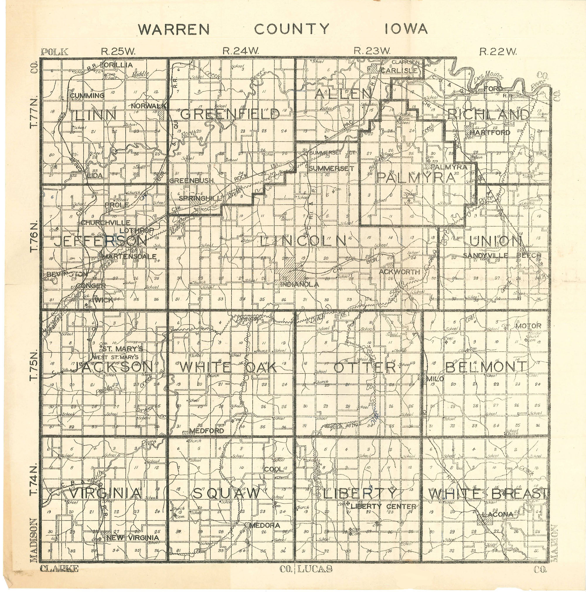
BEVINGTON – Located in the SW quarter of the NW quarter of section 30, Jefferson Township, Bevington started in 1872. See the location of Bevington on the 1902 Jefferson Township, Warren County map.
CARLISLE – The town of Carlisle started in section 3, Allen Township (see 1875 map on this site). Carlisle was formed by John Parmelee and Captain James Allen. They built a sawmill to furnish lumber for Fort Des Moines. Early residents included Jeremiah Church, Daniel Moore, Robert Nicholson, Frank Wood, Penn Sanders, Mathew Farley, William McKissick, and T. F. Allen. The town was named after Carlisle, Pennsylvania.
CHURCHVILLE – Churchville is located in section 8, Jefferson Township (see 1875 map on this site). John Churchman laid out the town of Churchville in 1854 on forty acres of the Michael Churchman farm. The railroad depot remained in service up to July 1921. The Church of the Assumption, the oldest Catholic parish in Warren County, was built in 1859, and burned on March 13 1933.
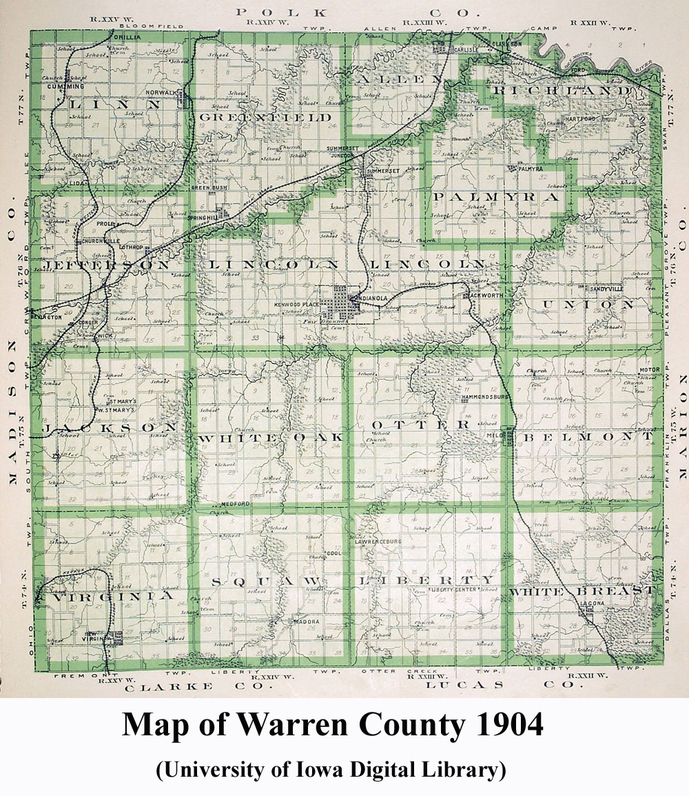
CLARKSON – Clarkson was located two miles east of Carlisle in the NE quarter of section 1, beside the Chicago, Burlington & Quincy Railroad. It was established because of the need for a shipping point on the railroad. It was named in honor of R. Clarkson of Iowa State Register fame. See the Warren County 1904 map for Clarkson east of Carlisle.
CONGER – Conger was located along the bottom line of section 29, slightly east of the middle of the line, in Jefferson Township. See a 1904 Warren County map of its location.. Conger was established as a railway station on the Chicago Great Western Railroad in 1888. The first store was built the same year by John F. Grissom.
COOL – Cool was located on the line between sections 11 and 12, Squaw Township, at the cross roads one-fourth mile north of the south line of the sections. See the 1904 Warren County map showing its location. Cool was sometimes called Fairview. There was a post office there between 1879-1904.
CUMMING – The town of Cumming was established in section 8, of Linn Township, following the arrival of the Chicago, St. Paul, and Kansas City Railroad. Cyrus G. Callison owned the land on which it was originally located. Cumming is the birthplace of U.S. Senator Tom Harkin. The town of Cumming was incorporated October 21, 1924. See a 1904 map for its location.
DERROUGH – The Derrough post office was established October 17, 1890 and discontinued August 31, 1892. Derrough was a county post office that served residents of Otter township, located in the SW quarter of the NW quarter of section 21.
DORRVILLE – Dorrville was located in the middle of section 19, Virginia Township.This was another hamlet established mainly as a post office between 1855-1863. The postmaster was Madison M. Melven. See the 1859 map of Warren County from the Library of Congress of its location.
ECONOMY (Orillia) – Economy was a post office and a railway station on the west edge of section 3 and east edge of section 4 in Linn Township along the Great Western Railroad. It was first known as Pleasant Ridge, where a cemetery by its name still remains.
ELLENDALE (Allendale) –Located in section 12 of Township 77 N, Range 23 W, in what is now Richland Township. It was about 2 miles southeast of Carlisle. See the 1850 Warren County map where it was part of the strip in Polk County. The town's name was originally Ellendale and changed to Allendale.
EVANSVILLE – Evansville was a trading center, never had a post office, and never became an incorporated town. At one time Mark Champlin built a group of small cabins which served the same function as today's modern motels.
FELIX (Taunton) – Located at the intersection of section 14, 11, and 12 in Belmont Township, Felix was a post office from 1876 - 1883 (previously called Taunton). An 1878 map shows the location of Felix.
FORD – The town of Ford was located in section 9, Richland Township (see the 1902 map of Warren County). It was not only on the railroad but on the river. It got its name in the early days being the fording place on the Des Moines River before bridges were built. It prospered with the coal mining business. Ford has become abandoned since the construction of Lake Red Rock.
FORT GIMLET – Fort Gimlet was also known as Gospel Ridge and Christian Neck, section 28 of Liberty Township.. It was the site of the Fort Gimlet Grist Mills.
FORT PLAIN - A village in section 8, White Breast Township. See the 1864 map of Warren County for its location on one of the original trails in Warren County converging at Indianola.
FRIENDS GROVE – This town was located at the top and center of section 23, East Lincoln Township, which was about a half mile north of Ackworth (see an 1873 map on this site shows its location). The post office operated from January 27, 1864 to November 14, 1865. Jeptha Morgan was the postmaster.
GENESVILLE – This apparently was a small trading center and may have been the site of a coal mine. This area was also once known by the nickname The Nation.
GOSHEN – Goshen was a Quaker settlement in the early days of Warren County.
GREENBUSH – Greenbush was located in the southeast corner of section 31, and northeast corner of section 6, Greenfield Township (see 1875 map on this site). Greenbush was one of the largest towns in the early settlement of Warren County with a post office from 1850 - 1854. This town diminished as the town of Spring Hill, located a mile southeast, grew.
HACKNEY'S GROVE (Handsome View) – Hackney's Grove was located in the SE corner of the NW quarter of section 11, in Squaw Township and had a post office from 1852-1853. J. Hackney owned the original land for Hackney's Grove. He later sold his land to Abe Smith and the name of the post office was changed to Handsome View. The Smith Cemetery remains in the area.
HAMMONDSBURG – Hammondsburg was located on a line between sectons 11 and 14, Otter Township, a little west of the midway part of the line and about two and one half miles northwest of the present town of Milo (see the 1875 map on this website). Robert G. Hammond established this settlement, the only one in Otter township, in the winter of 1846. The town began declining when the railroad was built near Milo. Houses and stores were placed on log rollers and moved to Milo. Hammondsburg had a post office from 1851-1879.
HANDSOME VIEW (Hackney's Grove) - Handsome View was located in the SE corner of the NW quarter of section 11, in Squaw Township. It had a post office from 1853-1859. It was previously called Hackney's Grove (see the 1855 map on this website).
HARTFORD – The town of Hartford began in section 21, Richland Township (see 1875 map on this site). Hartford was named by its original settler, John D. Hartford. It was named partly after his own name, Hart, and Ford, after the nearby ford of the Des Moines
HICKORY GROVE – Originally a Quaker settlement in section 3 of White Breast Township, Hickory Grove was settled as early as 1866. It contained a store, post office and church. Hickory Grove was sold to a group of German Catholics about 1870 where Rosemount Church was built. The town also has a cemetery, however; the graves from Hickory Grove Cemetery have been moved to Ackworth Cemetery and placed in a separate section east of the maintenance building.
HIGDONVILLE – Higdonville was a small trading center in Squaw township that never developed beyond a general store and a gas station. The log structure of the Ogle-Vickroy gas station is said to have been moved to the Iowa State Fair Grounds to the Indian Heritage Village.
HOOSIER ROW – Was located in the SE corner of the NE quarter of the NE quarter of section 16, White Oak Township. It got its name from the family of Albert Randolph and three brothers-in-law who moved in historic areaof Warren County. (See 1902 map of White Oak Township where Hoosier Row is listed simply as a school in section 16.)
INDIANOLA – Indianola was established at the crossroads of the Des Moines/Princeton, Missouri and Oskaloosa/Council Bluffs stage routes (see the 1875 map on this site of Washington Township). Indianola is the home of Simpson College. Dr. George Washington Carver attended Simpson and lived in Indianola from 1890-1891. The city of Indianola was incorporated Oct 5, 1863.
IRISH GROVE – Irish Grove, in section 19 of Virginia Township is sometimes confused with Dorrville because it was directly north of Dorrville and one post office and postmaster took the place of another. For its location, see the 1850 map on this website as well as the 1859 map of Warren County from the Library of Congress.
JEFFERSON (Lacona) – Willis and Elizabeth Clevenger were the owners of the land at the time Jefferson was platted. It was founded in 1856 and is one of Warren County's oldest continuous communities. The name was changed to Lacona on September 5, 1857 after it was discovered that there was already a town named Jefferson in Iowa.
JEFFERSON HEIGHTS – This community was a trading center and was a stage coach stop for travelers between Indianola and Osceola.
LACONA (Jefferson)–The town of Lacona is located in the center joining sections 21, 22, 27, and 28 in White Breast Township. Lacona was incorporated November 25, 1881. See the 1878 map showing its location..
LATIMER – Latimer was located in the middle of the east edge of section 30 and the middle of the west edge of section 29 in White Oak Township, and had a post office from 1861-1864. See the 1864 map on this website for its location.
LAWRENCEBURG – Lawrenceburg was located about midway of the north line of section 7, Liberty Township (see the 1875 map on this site). It had a post office from 1857-1879. The Lawrenceburg grist mill was one of the major businesses. The town also had a doctor and a school. The town was gone by 1900, but the school continued as a rural school until the 1950s.
LIBERTY CENTER – Liberty Center is in the center of Liberty Township (see the 1875 map on this site). Southeast Warren's consolidated school has built a junior and senior high school in Liberty Center.
LIDA (Loretta) - Lida was located slightly east of the middle of the southwest quarter of section 33, Linn Township. See the location of Lida in the 1902 Linn Township, Warren County map.
LORETTA (Lida) – This little village started in January 10, 1889 on the Edward McCusker farm in the south part of Linn township. The post office preceded Lida post office on the same site (section 33, Linn Township). It was discontinued December 5, 1889.
LOTHROP – Lothrop was located near the middle of section 14, Jefferson Township. The town was named in honor of Colonel Lothrop of Winterset. Lothrop ceased to exist some time after 1930. Many buildings were moved to Martensdale. See the location of Lothrop on the 1902 Jefferson Township, Warren County map.
LYNN – Lynn was on an old stage coach route that is now known as Highway 28 to Des Moines, in the southwest corner of section 3, Jefferson Township (see the 1875 map on this site). The Lynn Grove Church was built in 1869. There was a post office there from 1855-1872.
MARTENSDALE (Yaggy) – Martensdale is located where three separate railroads once came in very close proximity to each other in section 21, Jefferson Township. This is Warren County's newest community, incorporated October 29, 1920. See the 1930 map for this town.
MAYVIEW – Mayview was a rural post office in Otter Township. It was established July 30, 1900 and was closed September 30, 1901.
MEDFORD – In its earliest days Medford Located in the southwestern corner of section 32, White Oak Township, it had a post office from 1890-1903. For a map of its location, see the 1902 map of White Oak Township, Warren County.
MEDORA (Madora) – Medora (also called Madora) is located in section 27, Squaw Township (see the 1875 map on this site). It was an active trading center. At one time the town even had two doctors.
MILO – Milo originated in the NW quarter of section 19 in Belmont Township and the NE half of the NE quarter of section 24 in Otter Township. Milo was laid out in 1878 by S. H. Mallory along the Chicago, Burlington, & Quincy Railroad which ran through town. Many of the original stores in Milo were moved in from nearby communities, like the town of Hammondsburg in Otter Township and the town of Schonburg in Belmont Township. Milo was incorporated November 4, 1880. (See the 1904 map for its location.)
MONTPELIER – Little is know of the hamlet of Montpelier, located in the the southwest quarter of the northwest part of section 17, Jefferson Township. The post office operated from February 2, 1854 until October 16, 1860 (see the 1855 map on this website)
MOTOR (Waveland) – Motor was first called Waveland and began as a hamlet in the joined corners of sections 1, 2, 11, and 12, Belmont Township. The town of Motor had a post office from 1890-1902. A 1904 map on this site shows its location.
MURDOCK – At this time there is no information available and no map references for the location of this community.
NEW VIRGINIA – The town of New Virginia began in section 27, Virginia Township (see the 1875 map on this site). Many early settlers in southwest Warren County came from the state of Virginia, providing the name for this community. New Virginia's railroad station has been partially recreated in the museum of the Warren County Historical Society. New Virginia was incorporated April 29, 1901.
NORWALK (Pyra) – Norwalk was first located in the middle of section 13, Linn Township (see the 1875 map on this site). G. M. Swan brought his family to Pyra from Norwalk, Ohio. When Mr. Swan became its first postmaster, he changed the name of the post office to Norwalk. The town of Norwalk was incorporated June 15, 1901.
ORILLIA (Economy) - Orilla is a community on the west edge of section 3 and east edge of section 4 in Linn Township along the Great Western Railroad. Previously called Economy. Orillia is shown on a 1904 map of Linn Township, Warren County. It was once a stage coach stop between Des Moines in Polk County and Winterset in Madison County.
OSWEGO (Pryor) – Oswego was a stage coach stop between Indianola and St. Charles. It was located in the middle of the west edge of section 36, Jefferson Township and had a post office from 1864-1869. It was called the seven mile house. Pryor was the name of the post office which took the place of Oswego. An 1873 map on this site shows its location.
PALMYRA – The town of Palmyra is located in section 30 and 31 in Palmyra Township (see the 1875 map on this site). Palmyra was established on an old Indian Trail. The town site was chosen for its plentiful supply of game and good water.
PLAINVILLE – The town of Plainville was located in the southwest quarter of the southwest quarter of Section 32 of Belmont Township. It has a post office from 1855-1859. The cemetery is the only landmark remaining of this pioneer establishment.
PLEASANT HILL – A community listed in Warren County newspapers in White Oak Township, named after the Pleasant Hill Methodist Church, established in 1852, built in 1871, and rebuilt in 1901. The church was located in the northeast corner of section 20 (see 1875 map on this site).
PROLE (Spencerville) - Prole was located in 1884, in section 9, Jefferson Township. Prole was first called Spencerville and was named for Albert Western Prole, a pharmacist. See a 1902 map of Warren County, Jefferson Township showing the town of Prole.
PYRA (Norwalk)– Pyra was located in the middle of section 13, Linn Township and had a post office from 1856 - 1859. G. M. Swan brought his family to Pyra from Norwalk, Ohio, renamed the town to Norwalk, and became its first postmaster. See the 1859 map of Warren County from the Library of Congress which shows Pyra's location.
ROSEMOUNT – Rosemount was located at the corners of sectons 34 and 35, Belmont Township and sections 2 and 3, White Breast Township. It had a post office frmo 1864-1880. See the 1875 map of Rosemont in White Breast Township on this site. The vicinity of Rosemount was first settled by Quakers, then sold to a group of Germans. The church of St. Mary's of Perpetual Help, a parish house, and Rosemont cemetery are all that remain today.
SAINT MARY'S – Saint Mary's is located at the intersection of sections 9, Jackson Township (see the 1875 map on this site). The Immaculate Conception Catholic Church was established in 1870 and in 1891, Warren County's first Catholic school was built at St. Mary's. The town of Saint Mary's was incorporated April 5, 1923.
SANDYVILLE – Sandyville was laid out in 1851, located in the northeastern part of section 21 and the northwestern part of section 22, Union Township (see the 1875 map on this site). It had a post office from 1855-1903. Sandyville is another of those small Iowa communities that prospered until the railroad was relocated.
SCHONBERG (Bellemont) – Schonberg was located in the northwest corner of section 21, Belmont Township, about two miles east of the present town of Milo (see the 1875 map of this site). There was a post office there from 1871-1879. Schonberg was sometimes called Belmont Center.
SCOTCH RIDGE – Scotch Ridge was located on the western edge of section 10, Allen Township. The strength of the community started with its church which is still located there, on Highway 69,
SHARON – Sharon was located on the north line of section 2, Squaw Township (see the 1875 map on this site). It had a post office from 1861-1890.
SPENCERVILLE (Prole) – This place lasted such a short time it can hardly be classes as a town. It was the first name given to Prole. Prole is named for Albert Western Prole, a pharmacist who owned a drug and music store in Prole.
SPRING HILL – The town of Spring Hill is located in southwest quarter of section 5, Greenfield Township (see 1875 map on this site). Spring Hill became a thriving town when the railroad was built. It is named after the large spring that supplied the town with water.
SUMMERSET – This community started at the ford. on the south side of Middle River, section 31 of what is now Lincoln Township. Summerset was one of the earliest settlements of Polk and Warren Counties (since Polk County took the top tier of Warren County from 1846 to 1853). An 1850 map shows this town in existence where there was a mill and store. Summerset Junction was also formed along the Rock Island Railroad, on the north side of Middle River, which merged to become one town of Summerset, laid out in 1872.
SUTTON - Sutton was located in the middle of section 10, Palmyra Township. Sutton was listed in the United States postal records as having a post office from 1897-1900.
TAUNTON (Felix) – Taunton was established in the northeastern part of Belmont Township as a trading post in 1875 by Joseph Adamson, Francis Trueblood, and Nathan Adamson. It had a post office, coal mine, and grist mill, as well as the usual blacksmith shop, store, and wagon and harness shop. The name was changed to Felix on April 5, 1876.
THREE RIVERS - Located at or near the present town of Hartford, the village of Three Rivers had a post office between 1848 and 1854.
UNION HILL - This village was located in the southern part of section 9, Union Township as shown on an 1850 map of Warren County.
WAVELAND (Motor) – Waveland was a Quaker settlement, located in the joined corners of sections 1, 2, 11, and 12, Belmont Township. The community, church and cemetery and now known as Motor Friends Church and Motor Cemetery.
WESTFORD - Westford was located on Middle River at or near Summerset Junction, on the north side of Middle River in section 30, Lincoln Township. Its shown on maps from 1855 to 1868 (see 1855 map on this website). The town of Summerset grew up a little to the south of Summerset Junction in section 21, Lincoln Township.
WHITE OAK POINT - White Oak Point was located in section 30, White Oak Township and had a post office from 1852-1854 (see a 1859 Warren County map on the Library of Congress website).
WICK -Wick is located near the middle of section 33, Jefferson Township. It was established in 1883, about two years after the railroad was built. See the 1904 map on this website.
WILMINGTON - The town of Wilmington was located in section 24, Palmyra Township, about 3 miles northwest of Palmyra. A post office was there in 1855. The 1850 Warren County map on this website shows its location, as part of the strip belonging to Polk County (see Township Formation under the history section of this website for an explantion of the strip).
WISCONSIN - The village was located in the northern part of section 19, Belmont Township, at or near the town of Milo. It had a post office from 1865 to 1866 and a man named Pleasant Smith was the Postmaster. An 1873 map on this site shows its location.
Sources:
Warren County's Communities; There Were Eighty-two Of Them by Edith Conn, prepared for Iowa's Sesquicentennial Celebration in 1996.
Abandoned Towns, Villages, and Post Offices of Iowa, by David C. Mott, 1973
List of Incorporated Cities, by Iowa Secretary of State, Matt Schultz, 2012
Farm & Home Plat & Directory of Warren County, Iowa, by Farm and Home Publishers, 2007