|
|
Shelby County |

1911 GROVE TOWNSHIP PLAT MAPClick on map to enlarge.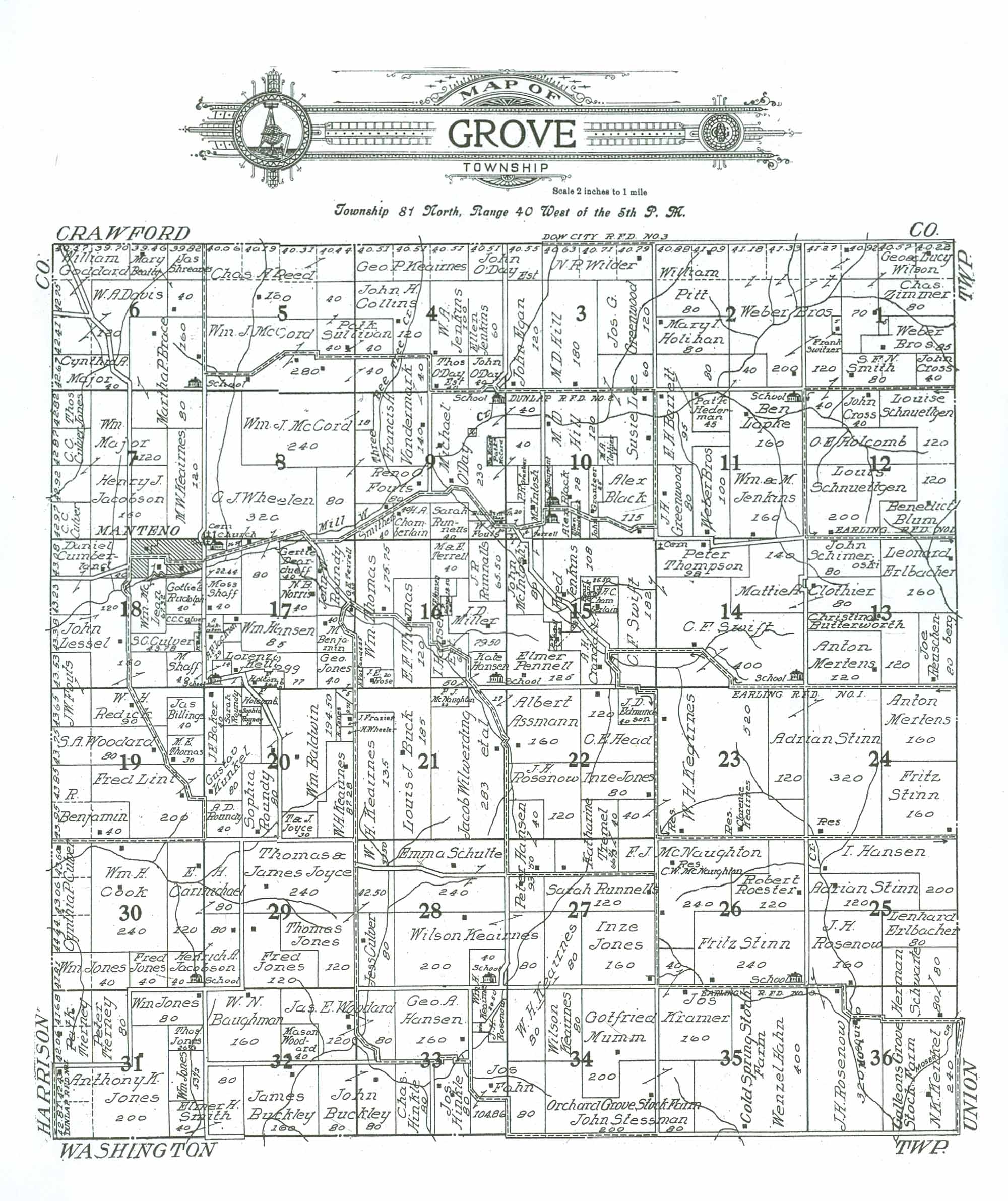 1911 GROVE TOWNSHIP RESIDENTS
|
| LAST NAME | FIRST NAME | SECTION # | ACRES | COMMENTS |
|---|---|---|---|---|
| Assman | Albert | 21 | 17 | |
| Assman | Albert | 22 | 160 | Owns property in adjoining Section 21 |
| Baker | J. E. | 20 | 40 | |
| Baldwin | Wm. | 20 | 194.5 | |
| Barrett | E. H. | 2 | 80 | Owns property in adjoining Section 11 |
| Barrett | E. H. | 11 | 95 | Owns property in adjoining Section 2 |
| Baughman | W. N. | 32 | 160 | |
| Beatty | Mary | 6 | 80 | 2 separate 40 acre parcels |
| Benjamin | M. | 17 | 40 | |
| Benjamin | R. | 19 | 40/120 | Map shows 40 acres, more like 120 |
| Billings | Jas. | 19 | 40 | |
| Black | Alex | 10 | 115 | |
| Black | Alex | 10 | 78 | Two bldgs of school and/or church located on western edge of property; 1 acre alloted to each. |
| Blum | Benedict | 12 | 120 | |
| Brace | Martha P. | 6 | 160 | "School" located in SE corner of property; Owns property in adjoining Section 7 |
| Brace | Martha P. | 7 | 80 | Owns property in adjoining Section 6 |
| Brod???? | Ellen | 10 | 10 | Acreage estimated |
| Buck | Louis J. | 21 | 185 | |
| Buckley | James | 32 | 160 | |
| Buckley | John | 32 | 80 | Owns adjoining property in Section 33 |
| Buckley | John | 33 | 80 | |
| Butterworth | Christina | 13 | 120 | |
| Carmichael | E. H. | 29 | 80 | Owns adjoining property in Section 30 |
| Carmichael | E. H. | 30 | 120 | Owns adjoining property in Section 29 |
| Cemetery | 14 | 2 | Located in NW corner of property owned by Peter Thompson | |
| Cemetery | 17 | 0 | Located on NW corner of property owned by O. J. Wheelen | |
| Chamberlain | H. A. | 9 | 40 | |
| Chamberlain | H. C. | 15 | 24 | Acreage estimated based on Section total |
| Church | 17 | 0 | Located on NW corner of property owned by O. J. Wheelen | |
| Clothier | M. A. | 10 | 15 | Acreage total difficult to read (tiny print). Estimated. |
| Clothier | Mattie A. | 13 | 80 | Owns property in adjoining Section 14 |
| Clothier | Mattie A. | 14 | 140 | Owns property in adjoining Section 13 |
| Collins | John H. | 4 | 120 | |
| Cook | Wm. H. | 30 | 240 | |
| Crandall | A. H. | 15 | 72 | Acreage estimated, based on Section total |
| Crandall | L. W. | 15 | 22.5 | 2 separate parcels of 20 and 2.5 acres |
| Cross | John | 1 | 40 | |
| Cross | John | 12 | 40 | |
| Culver | C. C. | 7 | 80 | 2 separate 40 acre parcels |
| Culver | C. C. | 18 | 10 | Acreage estimated; difficult to read number provided |
| Culver | Cynthia P. | 30 | 120 | |
| Culver | Jess | 28 | 80 | |
| Culver | S. C. | 18 | 43.78 | |
| Cumberland | Daniel | 18 | 120 | |
| Davis | W. A. | 6 | 160 | |
| Deardueff | Gertie | 17 | 40 | |
| Edmundson | J. D. | 22 | 40 | |
| Egan | John | 3 | 120 | |
| Erlbacher | Lenhard | 25 | 80 | |
| Erlbacher | Leonard | 13 | 160 | |
| Fahn | Jos. | 34 | 80 | Owns adjoining property in Section 33 |
| Fahn | Jos. | 33 | 104.86 | |
| Ferrell | ? | 10 | 4 | Acreage estimated |
| Fouts | J. W. | 18 | 40 | Owns property in adjoining Section 19 |
| Fouts | J. W. | 19 | 40 | |
| Fouts | Reno O. | 9 | 80 | |
| Fouts | W. A. | 9 | 20 | |
| Frazier | J. | 20 | 5 | |
| Goddard | William | 6 | 120 | |
| Granteer | J. | 10 | 5 | Acreage estimated |
| Granteer | John | 10 | 25 | |
| Greenwood | J. H. | 11 | 80 | |
| Greenwood | Jos. G. | 3 | 120 | |
| Ha?pent | ? | 10 | 9 | Small parcel located just north of northerly school/church on property of Alex Black |
| Hahn | Wenzel | 35 | 400 | "Cold Spring Stock Farm" |
| Hansen | Geo. A. | 33 | 160 | |
| Hansen | I. | 25 | 200 | |
| Hansen | J. E. | 16 | 13.5 | |
| Hansen | Kate | 16 | 50 | "School" located in SE corner of property. |
| Hansen | Peter | 22 | 40 | Owns property in adjoining Section 27 |
| Hansen | Peter | 27 | 93.5 | Owns property in adjoining Section 22 |
| Hansen | Wm. | 17 | 85 | |
| Hansen Est. | I. | 16 | 60 | |
| Head | C. E. | 22 | 120 | |
| Hederman | Pat'k | 11 | 45 | |
| Henderman | Pat'k (?) | 2 | 40 | Owns property in adjoining Section 11 |
| Hill | M. D. | 3 | 180 | |
| Hill | M. D. | 10 | 120 | |
| Hinkle | Chas. | 33 | 80 | |
| Hinkle | Jos. | 33 | 80 | |
| Holcomb | E. | 20 | 33.51 | Acreage estimated from Section total |
| Holcomb | F. | 17 | 20 | |
| Holcomb | O. E. | 12 | 120 | |
| Holihan | Mary I. | 2 | 80 | |
| Jack???? | A. | 17 | 6.06 | Small parcel, tiny print, difficult to read. Acreage estimated from Section total |
| Jackson | A. F. | 17 | 29 | |
| Jacobson | Henrich A. | 29 | 80 | Owns adjoining property in Section 30 |
| Jacobson | Henrich A. | 30 | 40 | Owns adjoining property in Section 29; "School" located in SE corner of property |
| Jacobson | Henry J. | 7 | 160 | |
| Jenkins | Ellen | 4 | 60 | |
| Jenkins | Fred | 15 | 108 | |
| Jenkins | W. A. | 4 | 100 | |
| Jenkins | Wm. & M. | 11 | 160 | |
| Jones | Anthony K. | 31 | 200/280 | |
| Jones | Fred | 29 | 120 | |
| Jones | Fred | 30 | 40 | |
| Jones | Geo. | 20 | 5 | Owns property in adjoining Section 17 |
| Jones | Geo. | 17 | 40 | |
| Jones | Inze | 22 | 80 | |
| Jones | Inze | 27 | 160 | |
| Jones | R. | 20 | 9.71 | |
| Jones | Thomas | 28 | 42.5 | Owns property in adjoining Section 29 |
| Jones | Thomas | 29 | 120 | Owns property in adjoining Section 28 |
| Jones | Thos. | 7 | 40 | |
| Jones | Thos. | 31 | 26.67 | |
| Jones | Wm. | 30 | 40/80 | Map reflects 40 acres, is actually 80 |
| Jones | Wm. | 31 | 80 | |
| Jones | Wm. | 31 | 53.33 | |
| Joyce | J. & J. | 20 | 30 | |
| Joyce | Thomas & James | 29 | 240 | |
| Keairnes | Geo. P. | 4 | 120 | |
| Keairnes | H. | 21 | 135 | |
| Keairnes | M. W. | 7 | 120 | |
| Keairnes | W. H | 23 | 520 | Residence of Clarence Keairnes located on property |
| Keairnes | W. H. | 20 | 87.28 | |
| Keairnes | W. H. | 22 | 40 | Owns property in adjoining Section 23 |
| Keairnes | W. H. | 27 | 80 | Owns property in adjoining Section 34 |
| Keairnes | W. H. | 28 | 37.5 | Owns adjoining property in Section 21 |
| Keairnes | W. H. | 34 | 80 | Owns property in adjacent Section 27 |
| Keairnes | Wilson | 27 | 80 | Owns property in adjoining Section 28 |
| Keairnes | Wilson | 28 | 200 | Owns property in adjoining Section 27 |
| Keairnes | Wilson | 34 | 80 | |
| Keairnes | Wm. H. | 28 | 40 | Owns adjoining property in Section 33; "School" located in SE corner of property |
| Keairnes | Wm. H. | 33 | 29.5 | Owns adjoining property in Section 28 |
| Kellogg | Lorenzo | 17 | 77 | "School" located in SW corner of property owned by Lorenzo Kellogg |
| Kenkel | N. K. | 36 | 240 | "Galleons Grove Stock Farm" |
| Kramer | Jos. | 35 | 160 | |
| Kramer | Jos. | 26 | 40 | Owns property in adjoining Section 35 |
| Kunkel | Gustav | 20 | 80 | |
| Lapke | Ben | 11 | 160 | "School" located in NE corner of property |
| Lee | Susie | 3 | 60 | Owns property in adjoining Section 10 |
| Lee | Susie | 10 | 105 | Acreage estimated from Section total |
| Lessel | John | 18 | 200 | Map shows both 120 and 160 acres; total appears to be 200. |
| Lint | Fred | 19 | 200 | |
| Major | Cynthia A. | 6 | 40/80 | Map indicates 40 acres, appears to be more like 80 |
| Major | Wm. | 7 | 160 | 2 separate parcels of 120 & 40 acres |
| McCord | Ch. | 9 | 10 | Acreage estimated from Section totals |
| McCord | Patk. | 9 | 20 | Acreage estimated from Section totals |
| McCord | Wm. J. | 4 | 40 | Owns property in adjoining Sections 5 and 8 |
| McCord | Wm. J. | 5 | 280 | |
| McCord | Wm. J. | 8 | 240 | Owns property in adjoining Section 9 |
| McCord | Wm. J. | 9 | 18 | Owns property in adjoining Section 8 |
| McIntosh | John | 10 | 3 | Owns property in adjoining Section 15 |
| McIntosh | John | 10 | 4 | Owns property in adjoining Section 15 |
| McIntosh | John | 15 | 80 | Owns property in adjoining Section 10 |
| McIntosh | P. R. | 10 | 45 | Acreage estimated |
| McLean | Wm. | 18 | 67.32 | |
| McNaughton | F. J. | 21 | 20 | |
| McNaughton | F. J. | 26 | 240 | Residence of C. W. McNaughton located on property |
| McNaughton | F. J. | 27 | 40 | Owns property in adjoining Section 26 |
| Mertens | Anton | 13 | 120 | |
| Mertens | Anton | 24 | 160 | |
| Miller | I. D. | 16 | 79.5 | |
| Mumm | Gotfried | 34 | 200 | |
| Norris | N. B. | 17 | 40 | |
| O'Day | Michael | 9 | 230 | "School" located in NE corner of parcel; owns property in adjoining Section 10 |
| O'Day | Michael | 10 | 80 | Owns property in adjoining Section 9 |
| O'Day | John | 4 | 40 | |
| O'Day Est. | John | 3 | 40 | Owns property in adjoining Section 4 |
| O'Day Est. | John | 4 | 40 | Owns property in adjoining Section 3 |
| O'Day Est. | Thos. | 4 | 40 | |
| Pennell | Elmer | 15 | 125 | "School" located in SW corner of property |
| Pitt | William | 2 | 80/160 | Map reflects 80 acres, appears to be more like 160 |
| Ran? | Frank | 15 | 26.5 | "L" shaped property located in center of Section |
| Redick | W. H. | 19 | 90 | |
| Reed | Chas A. | 5 | 280 | |
| Reuschenberg | Joe | 13 | 80 | |
| Roester | Robert | 26 | 120 | |
| Rose | J. E. | 16 | 20 | |
| Rosenow | J. H. | 22 | 120 | |
| Rosenow | J. H. | 25 | 160 | |
| Rosenow | J. H. | 33 | 25.64 | |
| Rosenow | J. H. | 36 | 320 | |
| Roundy | A. D. | 20 | 40 | |
| Roundy | John | 17 | 77 | |
| Roundy | Sarah | 20 | 20 | |
| Roundy | Sophia | 20 | 80 | |
| Roundy | Sophia | 20 | 10 | |
| Rudolph | Gotlieb | 17 | 22.44 | Owns property in adjoining Section 18 |
| Rudolph | Gotlieb | 18 | 40 | Owns property in adjoining Section 17 |
| Runnalls | J. R. | 16 | 65.5 | |
| Runnells | Sarah | 9 | 40 | |
| Runnells | Sarah | 27 | 120 | |
| Schimeroski | John | 13 | 80 | |
| Schnuettgen | Louis | 12 | 200 | |
| Schnuettgen | Louise | 12 | 120 | |
| School | 6 | 0 | Located in SE corner of property owned by Martha P. Brace | |
| School | 9 | 0 | Located in NE corner of property owned by Michael O'Day | |
| School | 11 | 0 | Located in NE corner of property owned by Ben Lapke | |
| School | 14 | 0 | Located in SE corner of property owned by C. F. Swift | |
| School | 15 | 0 | Located on SW corner of property owned by Elmer Pennell | |
| School | 16 | 0 | Located on SW corner of property owned by Kate Hansen | |
| School | 17 | 0 | Located in SW corner of property owned by Lorenzo Kellogg | |
| School | 26 | 0 | Located on SE corner of property owned by Fritz Stinn | |
| School | 28 | 0 | Located on SE corner of property owned by Wm. H. Keairnes | |
| School | 30 | 0 | Located in SE corner of property owned by Henrich A. Jacobson | |
| School or Church-? | 10 | 1 | Located in SW corner of Section on western edge of property owned by Alex Black | |
| School or Church-? | 10 | 1 | Located in SW corner of Section on western edge of property owned by Alex Black-?? | |
| Schulte | Emma | 28 | 240 | |
| Schwarte | Herman | 25 | 80 | Owns property in adjoining Section 36 |
| Schwarte | Herman | 36 | 80 | |
| Shaff | M. | 17 | 14 | Owns property in adjoining Section 18 |
| Shaff | M. | 18 | 40 | Owns property in adjoining Section 17 |
| Shaff | Moss | 17 | 40 | |
| Shreaves | Jas. | 6 | 40 | |
| Smith | Elmer H. | 31 | 40 | Owns adjoining property in Section 32 |
| Smith | Elmer H. | 32 | 80 | Owns adjoining property in Section 31 |
| Smith | S. F. N. | 1 | 80 | |
| Smithers | W. | 9 | 40 | |
| Stessman | John | 34 | 200 | "Orchard Grove Stock Farm" Owns adjoining property in Section 35 |
| Stessman | John | 35 | 80 | "Orchard Grove Stock Farm" Owns adjoining property in Section 34 |
| Stinn | Adrian | 23 | 120 | Owns property in adjoining Section 24 |
| Stinn | Adrian | 24 | 320 | Owns property in adjoining Section 23 |
| Stinn | Adrian | 25 | 120 | |
| Stinn | Fritz | 24 | 160 | |
| Stinn | Fritz | 26 | 240 | "School" located on SE corner of property |
| Sullivan | Patk | 5 | 80 | Owns property in adjoining Section 4 |
| Sullivan | Pat'k (?) | 4 | 40 | Owns property in adjoining Section 5 |
| Swift | C. F. | 14 | 400 | "School" located in SE corner of property. Owns property in adjoining Section 15 |
| Swift | C. F. | 15 | 182 | Owns property in adjoining Section 14 |
| Switzer | Frank | 1 | 5 | |
| Switzer | Frank | 12 | 40 | Owns property in adjoining Section 1 |
| Terrell | G. E. | 17 | 3 | Small parcel on eastern border of Section 17 |
| Terrell | M. & E. | 16 | 40 | |
| Thomas | E. F. | 16 | 120 | |
| Thomas | M. E. | 19 | 30 | |
| Thomas | Wm. | 16 | 175.75 | |
| Thompson | Peter | 14 | 98 | "Cemetery" located in NW corner of property; 2 acres allocated to it. |
| Tierney | Patk. | 31 | 80 | |
| Tierney | Peter | 31 | 80 | |
| Town of Manteno | 18 | 74 | Acreage estimated from Section total | |
| Tremel | Katharine | 22 | 40 | |
| Tremel | Katharine | 27 | 66.66 | Owns property in adjoining Section 22 |
| Unknown | 9 | 2 | Acreage estimated from Section totals; unable to read name; owns property in adjoining Section 10 | |
| Unknown | 10 | 20 | Tiny writing illegible; property in SW corner of Section, west of southerly School/church | |
| Unknown | 16 | 15.75 | Small writing, illegible name and acreage. Acreage estimated. | |
| Unknown | 18 | 5 | Acreage estimated; difficult to read tiny print | |
| Unknown: not allocated | 1 | 5 | Small parcel in center of Section; no name provided to parcel | |
| Vandermark | Francis H. | 4 | 40 | Owns property in adjoining Section 9 |
| Vandermark | Francis H. | 8 | 80 | Owns property in adjacent Section 9 |
| Vandermark | Francis H. | 9 | 140 | |
| Weber Bros. | 1 | 280 | 2 separate parcels of 85 and 195 acres; own parcels in adjoining Section 2 | |
| Weber Bros. | 11 | 100 | ||
| Weber Bros. | 2 | 280 | Owns parcels in adjoining Section 1 | |
| Wheelen | O. J. | 8 | 320 | |
| Wheelen | O. J. | 17 | 80 | Owns property in adjoining Section 8 |
| Wheelen | O. J. | 17 | 26.5 | "Cemetery" and "Church" located on NW corner of property |
| Wheeler | H. | 20 | 5 | |
| Wilder | N. R. | 3 | 120 | |
| Wilson | Geo. & Lucy | 1 | 150 | 2 separate parcels of 70 and 80 acres |
| Wilwerding et al | Jacob | 21 | 283 | |
| Woodard | Jas. E. | 32 | 120 | Owns adjoining property in Section 33 |
| Woodard | Jas. E. | 33 | 80 | Owns adjoining property in Section 32 |
| Woodard | Mason | 32 | 40 | |
| Woodard | S. A. | 19 | 80/120 | Map indicates 80 acres, is actually 120 |
| Zimmer | Chas. | 1 | 80 |
Transcribed by Denise Wurner, December, 2012.
Please notify the Shelby Coordinator of any transcription errors.