XVIII.
WHAT THE INDIANS OF IOWA GAVE UP pgs 162-174
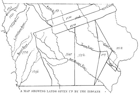
In Book One a short chapter told something about the Indians leaving the Territory of Iowa. But here it will be well to tell more carefully just what parts of the land they gave up at different times. The map may be helpful in showing what was done as the government of the United States arranged the different meetings where the treaties, that is the agreements, between the officers of the United States and the Indian chiefs were made.
As early as 1825 a line separating the Sacs and Foxes from the Sioux was drawn on this side of the Mississippi River. These tribes, it seems, were bitter enemies; they never forgot their earlier quarrels. The line at first was to begin at the mouth of the Upper Iowa River (in northwestern Iowa) and follow that stream up to the first fork; then up that fork to its source. |
pg 163 |
It then took a southwesterly direction across the Cedar River to the forks of the Des Moines River. From this point it went straight to the lower fork of the Big Sioux or Calumet River, and down that stream to the Missouri River. But because a certain band of the Sioux Indians was not present at the making of this treaty or agreement, the line from the Des Moines to the Missouri River was not fully settled.
The Ioway tribe and other Indians had some claim on the lands bounded by this line and the rivers on the east and west sides of the territory later belonging to this State. But the government promised to make everything right if there should be any faultfinding. The Ioways and the Sacs and Foxes were to occupy the region without quarreling until some decision could be made. Again, in 1830, the Sacs and Foxes, the Sioux, and other tribes promised to give up their claims to land in western Iowa, if they were allowed to hunt and fish there, as the President of the United States should direct them. Perhaps the tribes were to be given certain portions so that they would not get into trouble with each other.
The land which they were to use in that way was bounded as follows: beginning at the forks of the Des Moines River the line was to run north past the source of the Little Sioux and the Floyd River to the fork of the first creek which runs into the Big Sioux (or Calumet) River on the east side. It kept along this river and then along the Missouri to the line which formed the northern boundary of the state of Missouri. Then it followed this boundary eastward to the divide where the streams flow into the Des Moines on the east and the Missouri on the west. From that point it wound along the divide (watershed) between these two large streams until it had come opposite the Boyer River (See map), when it was drawn straight to the starting point (the fork of the Des Moines River).
It was the same year (1830) that the Sacs and Foxes and the Sioux were kept farther apart by a forty miles strip formed by laying off twenty miles on each side of the line which had been put between them in 1825. |
pg 166 |
It may have been strange enough to put forty miles of land between neighbors to keep them from fighting, but it should be remembered that Indians in their hunting might get a long way from home. Besides, they were not likely to pay much attention to a boundary unless it was a wide one. This wide boundary (in the northeastern part) was called the �neutral strip�; the Indians while there were not supposed to quarrel. At one time the tribe of Winnebagoes were allowed to live and hunt in this neutral strip but they were afterward (about 1848) moved to Minnesota.
The Black Hawk purchase of 1832 is readily seen on the map; it was bought at the close of the Black Hawk War which was mentioned in Book One. That fifty mile strip along the Mississippi meant about six million acres of land. The Indians got out about 1833, except as shown in the four hundred square miles kept for hunting along the Iowa River and where the village of Chief Keokuk was allowed to stay. In 1836, however, that four hundred square miles of hunting ground also was bought by the government. The Ioway tribe had some claim on that piece, too, and they were to be paid out of the money which the government had agreed to pay the Sacs and Foxes. All the Indians were to remove from the hunting grounds along the Iowa River by November 1, 1836, and never again should they �plant, fish, or hunt� on this land. We may wonder now what white men would have done had they been ordered to keep out in that way.
|
pg 168 |
At the time of the removal from the old camp the government agreed to give to the Indians about two hundred horses along with the money which had been promised for the four hundred square miles of land.
The narrow strip of such a queer shape which lies west of the old Black Hawk Purchase was bought in 1837. A million and a quarter acres were then added to the country which the white man might buy. In 1839 it was partly surveyed; the northern half was laid off by a line drawn straight west from a point on the Cedar River not far from the northern boundary of Johnson county. It extended west for twenty-five miles, fifty-one chains, and ten links. From the end of that line another was drawn sixty-nine miles two chains and thirty-two links north, or until it reached the boundary of the Black Hawk Purchase (See the map). That boundary line was then followed toward the southeast for seventy-five miles, fourteen chains and fifty links to the starting place on the Cedar River. In the northern half there were about 544,000 acres. When that part had been surveyed, there was some delay on account of the illness of the surveyor, Mr. Charles Bracken.
In 1838 the Ioway Indians, who seem to have been pushed about everywhere, gave up their claim against the United States for any land in the Territory of Iowa. Four years after that the Sacs and Foxes did the same thing; but they were not to leave all of the land until 1845. In the western part of the Territory they had been allowed to hunt and fish ever since 1830; and they were now permitted to remain there for three years after 1842 when the last treaty was made with them. But they could not come east of a line drawn north and south through the Painted or Red Rocks on the White Breast fork of the Des Moines river. By the treaty this line was to be so plainly marked that both Indians and white men could understand it; neither or them, it seems, should be allowed to go upon the territory of the other. At the present time the towns of Eldora, Newton and Knoxville will serve very well to mark that boundary line. After three years, of course, it was no longer needed.
Near where Des Moines is now, there was a government agent who distributed among the Sacs and Foxes the goods and money which the United States had promised them. Agents were always kept among the Indians to do this work, and they were moved westward as the land was given up. |
pg 171 |
By the treaty of 1842 the government agreed to provide each of the tribes (the Sacs and Foxes) with a shop and a blacksmith and a gunsmith; but the Indians were to pay the cost of the two shops.
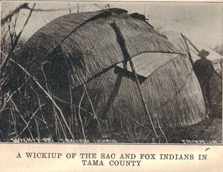
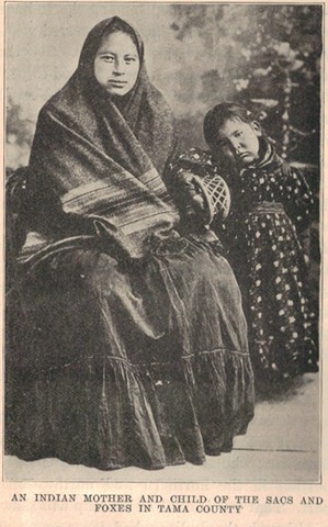
When these Indians had agreed to leave the Iowa hunting grounds in 1845, they were to have a home somewhere on the Missouri River or its branches. To be sure, that was a very uncertain home; and it was not liked by the tribes there when it was found. As was said in Book One, some returned and now own their own land in Tama County. For some time the Pottawattamies were allowed to live in the southwestern part of Iowa; their name has been kept in one of the largest counties of this State. The last of the tribes to give up any claim on Iowa was the Sioux, who at the time had only a small portion in the northern and northwestern part. That was in 1851 as the map will show.
Although the Indians had large sums of money paid them, the price was very small for the many thousands of acres which they gave up to the United States. Besides, it is well known that a large share of the money paid over went into the pockets of the white men who had sold goods to the Indians. These debts were to be paid out of the sums which the agents of the government were to distribute to the several tribes. When the money was sure to be paid, white men were very ready to get the Indians in debt to them.
The advance of the white man who formed territories, states, counties, and townships; who built roads and bridges, public buildings and railroads; who chose men to govern the towns, the townships, the counties, and the State, could not be stopped by the Indians. The Indian had no such thought; he wanted to be free to roam over a wide land, and to gather his living by hunting wherever he chose. He had certain leaders or chiefs and these had the respect of the tribes. But this kind of government had no capital city; it made no laws which men could read.
The wealth of the redman was found in his freedom to gather from the streams, the woods, and the prairies all that he really needed. When he grew a little corn his squaw did the work, while the Indian brave prepared his bow and arrows for the next hunt.
The Indian loved his hunting grounds better than a cultivated field. He gave up his claims on the rich land of Iowa, and now many thousands live where hundreds lived before.
|