THE ROADS OF THE WHITE MAN pgs 14-18
The first white men who came to Iowa to live made homes along the Mississippi River. In such places they could go by boats up and down the stream; and when they moved farther back from the large river they usually found a smaller stream near which they could make their home. The Indians kept canoes all along the streams and the white man could soon do as well.
It was not long, however, until some wished to go across from one settlement to another; or even from one home to another at some distance, but not on the same stream. Sometimes, of course, teams of oxen or horses must cross the prairie, and very early men began to think of roads quite different from those which followed the Indian paths.
First, from farm to farm in the direction that men wanted most to go these roads were laid out. For that reason they took the shortest, or the most direct course. And it is for that reason, too, that the first roads ran along the ridges of high land. In the low ground there were sloughs of soft earth where loads could not be drawn without much trouble, because the wagon wheels would settle down so deep. Very often these sloughs had to be crossed and they were often worse than the rivers to get over.
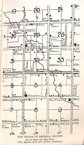
Those who live in the eastern part of Iowa may readily find these early roads, but they are not so common in the newer part of the State. The reason may be given better at some other place, but any owner of land can tell why and the map on page 17 may be of some help in understanding it. Because land was laid out, that is surveyed, in the western part of Iowa before roads were needed, these later roads are like a checker board and have corners everywhere. They are not so interesting as the crooked roads of eastern Iowa.