Maps, Towns & Townships
![]() Franklin County, Iowa
Franklin County, Iowa
Maps, Towns &
Townships
~*~*~*~
Franklin
County had 9 townships in 1871
Clinton, West Fork, Morgan, Washington, Ingham, Geneva, Reeve,
Oakland and Oscola
Franklin County had
14 townships in 1875
Richland, Clinton, West Fork, Morgan, Marion, Washington, Ingham,
Hamilton, Reeve, Geneva, Oakland, Lee, Grant and Oscola
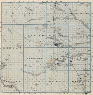
Illustrated Historical Atlas of the State of Iowa, A.T.
Andreas, 1875
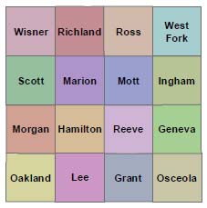
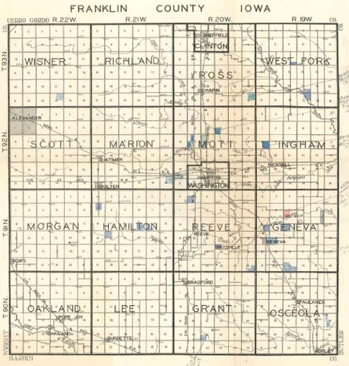
There are
now sixteen townships
Wisner, Richland, Ross, West Fork, Scott, Marion, Mott, Ingham, Morgan, Hamilton, Reeve, Geneva, Oakland, Lee, Grant and Osceola
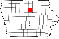
Franklin County lies in the third tier south
of Minnesota and in the fifth west of the Mississippi
River. It contains sixteen townships making an area of
five hundred seventy-six square |
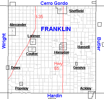 |
 Franklin County Township Map - W.W. Hixon Plat Book, 1930 |
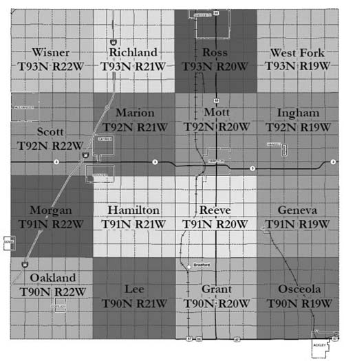 Map is from Geographic Information System (GIS) |
Current
Communities in Franklin County
| Town | Township |
| Ackley *website *Google map |
Osceola (partly in Hardin County) |
| Alexander *Google map |
Scott |
| Bradford *Google map |
Grant |
| Burdette *Google map |
Lee |
| Chapin *Google map |
Ross |
| Coulter *Google map |
Scott, Marion, Morgan, Hamilton |
| Dows
- originally named Otisville *Google map |
Morgan (partly in Wright County) |
| Faulkner *Google map |
Osceola |
| Geneva *Google map |
Geneva |
| Hampton
- originally named Benjamin - Franklin Co. Seat - *website *Google map |
Washington, Mott |
| Hansell *Google map |
Ingham |
| Latimer *website *Google map |
Marion |
| Oakland *Google map |
Oakland |
| Popejoy *Google map |
Oakland |
| Sheffield *website *Google map |
Ross |
Historical, Abandoned & Defunct Communities in Franklin County
Chapin
A village platted in 1858 in section 36, Richland township and section 31, Clinton township. Itwas abandoned in the early 1870's on the building of the railroad two miles to the east and the laying out of the present village of Chapin. Coldwater
A post office from 1867 to 1875 in the northeastern part of Westfork township. In the latter year it was removed over the line into Butler County. Congress
In the northeastern corner of section 36, Hamilton township. Post office, 1873-75. Cream Hill
In section 24, Ingham township. Post office, 1878. Elide
Listed in the 1873 U.S. Official Register as a post office in Franklin County, but not
found on the maps of that period. May have been in Reeve township.Ingham
In the northwestern part of section 16, West Fork township. Post office, 1867-75. Maysville
In section 27, Reeve township. It was the first town platted in the county,being laid out in 1856. It was prosperous and came near getting the county seat. Post office, 1857-89. More information at the Maysville website (link opens a new window) Menzie
In section 16, Ingham Township. Post office, 1871-76. Oakland Valley
A village in the northeastern part of section 28, Oakland township, near the south bank of the Iowa River. It was platted in 1857 and was prosperous for a time. Post office, 1862-97. Otisville
A hamlet in sections 30 and 31, Morgan township, Franklin County and sections 25 and 36, Blaine township, Wright County, near where the town of Dows now stands. When the railroad came the name was changed to Dows. The post office was Otisville from 1857 to 1880. Reeve
In section 30, Reeve township. Post office, 1893-1900. Shobe's Grove
In the northeastern part of Richland township. Post office, 1863-73. Union Ridge
In the northeastern part of Ingham township. Post office, 1859-75. Washburn
In the southeastern part of Ross township. Post office, 1871.
~Source of information: Annals of Iowa, Vol XVII, January 1931, Abandoned Towns, Villages & Post Offices of Iowa; pg 10-11
|
This
page was last modified on April 29, 2016
©2016 by IAGenWeb & the various submitters.