
DECATUR COUNTYCounty Inventory Map With Historical & Conservation Points of Interest (prior to 2000)Developed by USDA Corporation with the Decatur County Rural Development Committee Design and Drafting by Eldon L. Thomas. |
|
 |
|
 |
 |
 |
 |
|
|
|
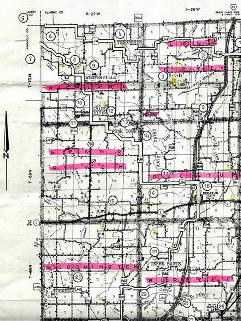
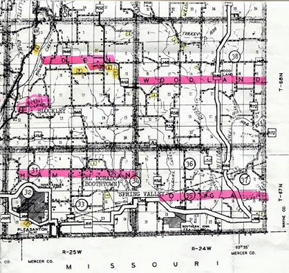
| 1 The Town of Van Wert 2 Site of the Del Ray Railroad Station 3 Decatur Wildlife Area and Site of Settlement of DeKalb 4 Tennessee Church and Site of Settlement of Little Tennessee 5 Four Corners 6 Scenic Ridge Road to Westerville 7 Sand Creek Wildlife Area 8 Soil Conservation Measure: Diversion Terrace 9 Westerville 10 Horse Thief Cave 11 Soil Conservation Measure: 12 Shewmaker Park 13 Site of Funktown (Oak Hill Cemetery) 14 Diamond School House 15 Elk Chapel Church and School House 16 Woodmansee Stagecoach House and Barn (Max Albaugh Residence) 17 Springer Woods (Private) 18 Decatur City 19 Little River Watershed Structure Site 20 City of Leon 21 Terre Haute (Site of Pioneer Trading Post) |
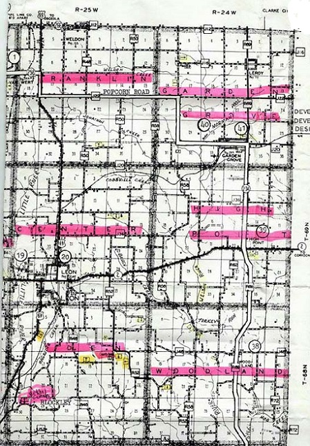
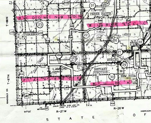
22 Soil Conservation Measure: Grade
Stabilization Structure 23 Tuskeego 24 Liberty Home 25 Graceland College 26 Slip Bluff Park 27 Location of Strington School House 28 Union Church Built by John Clark in 1878 29 Soil Conservation Measure: Tile Intake Terraces 30 New Buda (Site of Hungarian Settlement and Home of Decatur County's Civil War General George Pornutz) 31 Scenic Road 32 Nine Eagles State Park 33 Soil Conservation Measure: Farm Pond 34 Spring Valley (Old Town Site on Little River) 35 Site of Agricultural Experimentation 36 Morgan Center Town Site 37 Scenic Ridge Road between Steel Creek and Woodland 38 Town of Woodland 39 Former Site of Town of High Point now marked by High Point Church 40 Mormon Cemetery amid Scenic Beauty 41 Town of Garden Grove and Site of several Classic Buildings |
| Information provided by Nancee (McMurtrey) Seifert |
| Maps *** Decatur County IAGenWeb |