

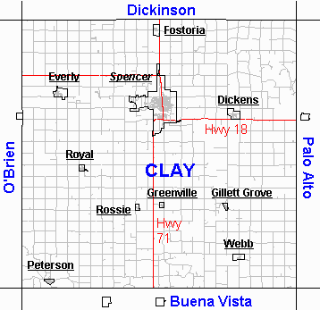
Incorporated Communities
DICKENS was first settled by the Dickerson brothers in 1880 and believed to be one source for the "Dickens" name along with the story of a lady exclaiming "Dickens" when their first town name choice was already taken.. Population was 202 in 2000 and 185 in 2010. The city has a total area of 0.84 square miles.
EVERLY was settled in 1884 and originally named Clark after a local farmer, but after finding another Iowa town by the name of Clarke, they changed it to Everly. The Everly Bank was robbed by Bonnie and Clyde on May 3,1934 and is believed to be one of the last banks robbed by the duo. Everly incorporated on April 7, 1902. The population was 603 in the 2010 census and 647 in the 2000 census. The city has a total area of 1.11 square miles. Website
FOSTORIA was first settled in 1882 due to the railroad line from Spencer to Spirit Lake.In 1895,a group of farmers created the Fostoria Creamery Company that earned the reputation for the best "sweet cream butter." This butter was shipped and sold in New York City until after WWII when population of dairy cows declined in the area and the creamery was closed. The population was 231 in the 2010 census and 230 in the 2000 census. It has a total area of 0.47 square miles.
GILLETTE GROVE First settlers appeared in 1856 and the town, named after the Gillett brothers, [George and Isaiah] was incorporated in 1874. The town was originally located west of the river and one and a half miles north until 1899 when it was moved to the east side of the river along with the arrival of the railroad. The population was 49 in the 2010 census and 55 in the 2000 census., the city has a total area of 0.19 square miles
GREENVILLE Albert and Lizzie Greene settled in 1869 half mile south of the current location. 1900 saw the railroad pass through from Storm Lake easily connecting Greenville to both communities. Greenville was incorporated in 1916. The town also was the earliest Friends Church in Clay County, being present from 1879 until 1961 when the church closed. The Greenville post office opened in 1871. The first postmaster was A. W. Green. The population was 75 in the 2010 census and 93 in the 2000 census. The city has a total area of 0.18 square miles
PETERSON The first settlement was made at Peterson in 1856. In 1862 a fort was built in Peterson by settlers to defend against anticipated Dakota attacks during the Dakota War of 1862. The fort was never attacked. The blockhouse from this fort still stands near its original location at the corner of Second and Park. Peterson was platted in 1881 when the railroad was extended to that point. The city was named for Adlie Peterson, an early settler. The population was 334 in the 2010 census and 372 in the 2000 census. It has a total area of 0.31 square miles.
Peterson was established in 1856 by a small group of families including the Kirchners. The Kirchners were visited on November 23, 1856, by Inkaputa's band of Native Americans. Inkapua's band visited again on February 14, 1857, before going north to Spirit Lake.[Spirit Lake Massacre] Originally the Kirchners called the area "Long Grove" and Howard Peterson, owner of the mill, wanted to name the area "Howard" but due to another Howard, Iowa the federal postal department named the area Peterson instead. The first frame house was built by the Kirchners and still stands in Peterson along with another Kirchner home in town available for tours. The first county seat was Peterson from 1860 until 1871 when the county put it to a vote and moved the seat to Spencer.
ROSSIE began in 1900 as the Chicago Rock Island and Pacific Railroad line passed through the county from Des Moines to Sibley. Originally residents wanted to name the community Davis but due to Davis, Iowa already existing they came up with Rossie. Rossie was incorporated in 1923 and had one of the few banks in the county to survive the Great Depression. The population was 70 in the 2010 census and 58 in the 2000 census. It has a total area of 0.15 square miles.
ROYAL started April 27, 1900, when Mr. C. Mortensen purchased 160 acres from the Northern Iowa Land Company. Lots were platted soon after. Eliza Nelson chose the name of Royal as the first postmaster of the town. Royal was incorporated in 1910. The population was 446 in the 2010 census and 479 in the 2000 census. It has a total area of 0.30 square miles.
SPENCER The first house was built in what is now Spencer in 1866, and the first store was opened there in 1869. Spencer was platted as a town in 1871. In 1878, Spencer experience growth when the Chicago, Milwaukee & St. Paul Railway was built into the settlement. It is located at the confluence of the Little Sioux and Ocheyedan Rivers. The population was 11,233 in the 2010 census and 11,317 in the 2000 census.Spencer is famous as the home of the Clay County Fair, held annually in September, averaging over 300,000 visitors each year. The town's (now-deceased) library cat, Dewey Readmore Books, is known throughout the world. The city has a total area of 11.18 square miles, of which, 11.01 square miles is land and 0.17 square miles is water. Spencer Leaders 1880-2008. Spencer City Website.
WEBB was founded in 1900 as a rural based community with strong familly values. Webb was originally known as Glenora, but F.D.White changed the name to Webb, in honor of his mother's maiden name. The town once boasted four grocery stores, two creameries, three filling stations, and a band stand. Stores were open on Saturday nights and free movies were shown in the summer. Disaster struck the town in 1913 and 1914 when fire destroyed first the east business block and then the west business block of the town. The population was 141 in the 2010 census and 165 in the 2000 census. It has a total area of 0.50 square miles. Website
Unincorporated Communities
CORNELL was platted in 1900-1901 when the Minneapolis and St. Louis Railroad passed through the county from Storm Lake to Jackson, MN., before going to Minneapolis. Cornell prospered with an elevator, telephone company, Post Office, General Merchandise Store, Methodist Chuch, roller skating rink, Cornell Shipping Association, Fire Department, and a school. The railroad left Cornell on April 20,1936, and impacted many businesses. The school closed in 1967 and students were transferred to Webb or Sioux Rapids. The post office closed November 3, 1967, and became a rural route. Cornell is located near Hwy 71 and is 3.6 miles north of Sioux Rapids.
LANGDON was platted in 1899 just after the railroad going north and by 1901 settlers were building around the railroad in present day Langdon. Langdon is located along county road B17 and M50, 5.6 miles north northeast of Spencer.
MONETA is on the O'Brien county side of the O'Brien/Clay line. It was platted in 1901. The population was 87 in 1915, but in 1997 the population was down to 29 and Moneta unincorporated. It is located on the corner of 100th Avenue and 360th Street on B24.
Information from Wikipedia and Clay County Tourism.
Abandoned Towns, Villages, and Post Offices of Clay County
ANNIEVILLE: in the southeastern part of section 12, Lincoln Township. Post office, 1871-1880.
BRIDGEWATER: in the southeastern part of Lake Township. Shown on maps from 1873-1887.
CLARK: first name give to town of Everly. Platted as Clark in 1884. Listed as Clark in U.S. Postal Guide from 1885-1897.
CROMWELL CENTER: west of the central part of Summit Township. Post office, 1875-1900.
DOUGLAS CENTER: in section 24, Douglas Township. Post office, 1871-1875.
FREEMAN: in the northeastern corner of section 13, Sioux Township. Post office 1871-1875.
HERDLAND: in section 14, Herdland Township. Post office 1881-1897.
PLATT: listed in the U. S. Postal Guide as a post office in Clay County from 1893 to 1897.
PROSPECT: in the northwestern part of Meadow Township as shown on maps from 1873-1885.
SUMMIT: in section 24, Summit Township. Post office, 1875.
TRIMELLO: in section 6, Clay Township. Post office, 1875-1900.
WILLOW CREEK: in section 36, Clay Township. Post office, 1871-1900.
YANKEE: in the north central part of Peterson Township. Post office, 1881-1900.
From "The Annals of Iowa", Volumes XVII and XVIII, 1930-1932