The USGenWeb Project
Benton County, IAGenWeb Project
HOME SEARCH WHAT'S NEW SITE MAP
The IAGenWeb Project

Benton County, Iowa
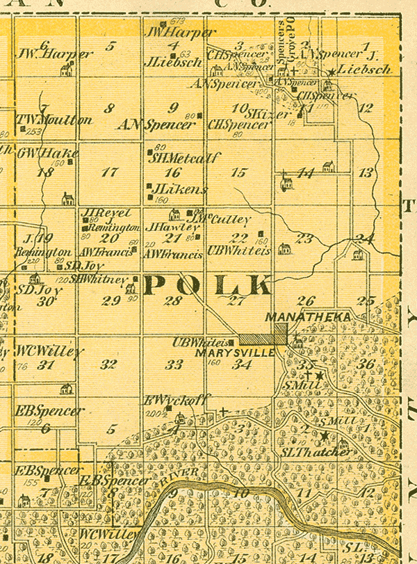
Polk Township 9 W Range 86 North
A.T. Andreas' Illustrated Historical Atlas of the State of Iowa, 1875

Polk Township Map

--------------------------------------------------------------
 Section     Name                                      Acres
--------------------------------------------------------------
       2     Spencer's Grove P.O.
       2     A.N. Spencer                                -
       2     Baptist Church                            
       2     Spencer's Grove Cemetery                  
       2     J. Liebsch                                  -
       3     C.H. Spencer                                -
       3     A.N. Spencer                                -
       4     J.W. Harper                               673
       4     J. Liebsch                                 63    
       6     J.W. Harper                                 -
       7     T.W. Moulton                              253    
       9     A.N. Spencer                               80
      10     A.N. Spencer                              400    
      10     C.H. Spencer                               80
      11     S. Kizer                                   18    
      11     C.H. Spencer                              11*    
      14     St. Mary's Church (now in Urbana)
      16     S.H. Metcalf                               80
      16     J. Likens                                 160    
      18     G.W. Hake                                 160    
      19     J. Remington                              220    
      19     S.D. Joy                                   80
      20     J.I. Revel                                 80
      20     J. Remington                               80
      20     A.W. Francis                               80    
      21     J. McCulley                               120    
      21     J. Hawley                                  80    
      21     A.W. Francis                               20
      22     U.B. Whiteis                              160 
 26 & 35     Manatheka (now known as Urbana)
      29     S.H. Whitney                               90    
      30     S.D. Joy                                  120
      31     W.C. Willey                                76
      34     U.B. Whiteis                              160
      34     Marysville (now known as Urbana)
      35     Christian Church                          
      35     Cemetery (now known as Urbana Cemetery)
      35     S. Mill   [saw mill?]                       -   
   So. 2     S. Mill   [saw mill?]                       -   
   So. 2     S.L. Thatcher                              10
   So. 3     Kisling Cemetery                                  
   So. 4     E. Wyckoff                                200 1/2
   So. 6     E.B. Spencer                              120
--------------------------------------------------------------
Notes:
Section So. 4:  Cox Cemetery. Not shown on map, but existed in 1875.
Section 14:  St. Mary's Cemetery. Not shown on map, but existed in 1875.


Monroe Township    St. Clair Township

1875 County Map  1875 Name Index

Transcribed by Sue Soden.
Copyright © 2007 by Sue Soden.
All Rights Reserved.


If you note any corrections, changes, additions, or  find any links provided on this web site that are
not  functioning properly please notify  John Shuck, your Benton County Website Coordinator.

Copyright © 1997-2024. This web site was created solely for the
use and benefit of the IAGenWeb Project
a part of the USGenWeb Project.
All Rights Reserved.