A Fascinating Report By Boundary Surveyors
The Story Behind an Early Iowa Land Swindle
By Otto Knauth
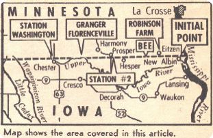
Map showing the area covered in the following
article
The year was 1852. Although Iowa had been a state
for six years, its northern hills and prairies were
on the edge of the frontier, uninhabited, unsurveyed,
many of them unexplored. Iowa's northern border with
Minnesota territory had been fixed at the parallel of
43 degrees and 30 minutes north latitude by the 1846
Constitution but in 1852 nobody knew where it was. It
was an imaginary line in space that had no meaning on
the ground.
A survey was needed, a mile-by-mile marking of the
line so settlers and tax collectors and sheriffs
would know where they were. Such land surveys had
been started in Iowa in 1836 with William A. Burt's
survey of the Fifth Principal Meridian in eastern
Iowa. From that line, township and section surveys
spread an ever-widening network across the young
state.
ONE OF THE IRONIES OF THE
SURVEY
But the survey of a degree of latitude more than
250 miles long posed a different problem. Such a
line, because of the curvature of the Earth, curves
constantly but ever so slightly to the north. It is
not noticeable over a mile or even five miles but the
curve is there nevertheless and if the line is to be
accurate, it must curve. And this line had to be
accurate. Not only would it mark section and township
and the border between two states, it would also
serve as the base line for all the future surveys in
Minnesota and the Dakotas. A mistake would result in
endless squabbles over land, taxes, elections and all
the other institutions peculiar to western
civilization.
One of the ironies of the survey is that, because
of its very accuracy, it became the basis for one of
the early Iowa land swindles.
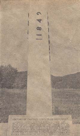
To get the survey started, the U.S. Surveyor
General first ordered an accurate determination of 43
degrees and 30 minutes north latitude. Capt. Thomas
J. Lee of the U.S. Topographical Engineers was
ordered to determine the beginning of the boundary
line on the west bank of the Mississippi River in the
summer of 1849. He picked a spot about three miles
from the channel, made a long series of observations
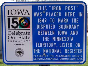
of the stars and planets and set up a cast-iron
pillar five feet high and weighing 600 pounds with
the words "Iowa" and "Minnesota"
and "1849" and "Lat. 43° 30"
engraved on it. Records show he paid $57 for it,
buying it in Lansing on Oct. 18, 1849.
The monument is still there, in an out-ofthe-way
corner at the north edge of New Albin, surrounded by
a lumber company's logs and stored farm machinery. It
is a target for beer bottles whose shards litter the
base. A cast-iron plaque explains its significance.
Of all the hundreds of markers set along the line by
the original survey, it is the only one remaining.
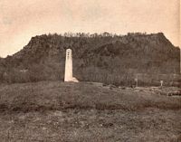
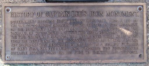
Captain Lee's Iron Monument still stands
at the north edge of New Albin.
It is the only original boundary marker in evidence
today.
Using Captain Lee's monument as a base point, the
border survey was to get under way the next year but
the magnitude of the undertaking and the outbreak
of an epidemic of Asiatic cholera delayed it until
1852. The expedition was placed in charge of a deputy
U.S. surveyor, Capt. Andrew Talcott of Washington,
D.C. According to a later reminiscence, it consisted
of 14 surveyors, a doctor, a hunter, an interpreter,
four cooks, and chainmen, flagmen, monument builders,
teamsters, wood choppers and general handymen. All
told, some 43 men were sent into the field, no small
force for such a task in those days.
BUT IT WASN'T QUITE THAT SIMPLE
Recently, one of two copies of Captain Talcott's
final report on the survey and a bound volume of the
original field notes of the survey teams were
rediscovered in the archives or the Iowa Secretary of
State's office in Des Moines. In 378 painstakingly
handwritten pages, Talcott gives the surveyor
general's instructions to him, his own instructions
to his deputies, the astronomical calculations needed
to stay on the line and the actual survey itself, a
page or more for each mile. It is a fascinating
report on Iowa as it once was, on the land as the
white man found it, when bands of Sioux still ruled
the prairies and buffalo and elk roamed unfettered
and unfenced.
Logically, one would expect the survey to start at
Captain Lee's iron monument near the Mississippi and
run west from there, But it wasn't that simple, since
only the north-south position of the monument was
known and not the east-west. So Talcott was
instructed to begin his survey where the known Iowa
survey ended, at a point identified as the corner of
Townships 99 and 100 north and Ranges 4 and 5 west of
the Fifth Principal Meridian. This is now the corner
of Iowa, Lansing, French and Union Townships in
Allamakee County. It is about three-quarters of a
mile south of the Upper Iowa River and about 4¾
miles south of the border. From here, the surveyors
worked north until they intersected a line drawn
westward from Captain Lee's monument. This
intersection was identified as the "Initial
Point" of the survey.
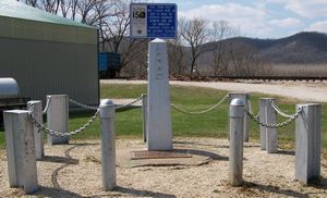
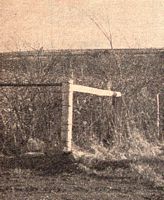 |
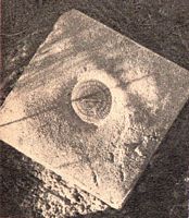 |
 |
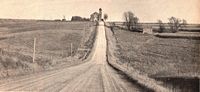
The boundary survey's "initial
point", where surveyors coming up from
the south (background) started the survey.
|
A bronze geological survey plate whose
arrow points west
along the border.
|
A "witness post" calling
attention
to the "initial point" marker.
|
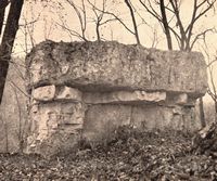
Along the way, about 2½ miles north of the
river, they encountered a "perpendicular rock 10
feet high." A huge square boulder fitting that
description still lies on the shoulder of a hill in
the woods above what is known as "Irish
Hollow," a few miles west of New Albin.
It was in establishing the "Initial
Point" that the basis for the later land
swindles was laid. The Iowa surveys were based on the
intersection of the Fifth Principal Meridian and the
National Base Line, a point about 70 miles east of
Little Rock, Ark. From here, the ranges and townships
were called north and west into Iowa. In the standard
survey, each township is divided into 36 mile-square
numbered sections, with the numbering starting in the
northeast corner. Thus, the northernmost row of
sections in any standard township is numbered 1-6,
the second row, 7-12, and so on.
SHARP LAND PROMOTER GOT IN HIS
LICKS
In carrying the Iowa survey north to the border,
the surveyors found they were still in the second row
when they reached the border. They had run out of
Iowa before completing the township. And a section
map of Iowa will show that all along the entire
northern border, in every county, sections 1-6 are
missing. The count everywhere starts with Section 7.
In the late 1850s, so the story goes, some sharp land
promoter noticed the missing sections and started
selling them sight unseen to emigrants from Ohio and
Indiana. These unfortunate families arrived to claim
their land and found it didn't exist. Years later, a
county historian wrote: "Tradition has it that
this man died childless and that at his death, the
last of the dishonest real estate agents disappeared
off the face of the earth."
The "Initial Point" now is identified by
a U.S. Geological Survey marker stamped "Iasota
No.4" across the border road from the William
Beneke home in Minnesota. Here then, where county
road N crosses the border, on a high ridge with a
wide view to the south, is where the great survey
started.
From here the surveyors turned west and the hard
work began. A series of eight stations was set up
whose latitude was determined accurately by
astronomical observations. These stations were an
average of about 36 miles apart and, after the first
two, were named after U.S. presidents, beginning with
Station Washington, just east of the Upper Iowa River
near where the Howard County town of Chester now
stands. Station Adams was just west of the Shell Rock
River in Worth County; Station Jefferson, on the
middle branch of the Blue Earth River in Kossuth
County; Station Madison, just west of Spirit Lake in
Dickinson County; Station Monroe, on Little Rock
River, in Osceola County, and Station Jackson, on the
east bank of the Big Sioux River, in Lyon County. The
Initial Point was Station 1; Station 2 was located on
a branch of the Root River, in Winneshiek County.
HOW THE CURVING LINE WAS THEN
ESTABLISHED
Straight guide lines were run by transit sights
between these stations, and the curving line of the
boundary was established by running measured offsets
from the guide lines.
Station Washington became headquarters for the
survey. Here was established the principal supply
depot and it was on his arrival here that Talcott
divided his expedition into four parties.
One, with 11 members and under the direction of
Deputy Surveyor John M. Marsh, was to move ahead of
the main party, surveying the line with a solar
compass invented by Burt, both to test the accuracy
of the new instrument and to provide the main party
with some idea of what it could expect in the country
ahead. Marsh's was to be the exploratory party.
Years later, one of the men in Marsh's party
wrote: "His line proved to be perfectly correct.
Had the United States let the contract to Capt. Marsh
at $25 per mile, it would have cost the government
but $6,500 (the actual cost was about $32,000) and
would have been run and marked as well."
HIGH CLIFFS, DENSE WOODS HAD
LITTLE APPEAL TO THEM
The second party, also 11 in number and under
Deputy, Harry Taylor, was to survey the guide lines
connecting the astronomical stations. The third, six
in number under Deputy John S. Shellar, was to act as
a check on the second and place monuments at the
appropriate corners. And the fourth party, under
Talcott himself, was to make the astronomical
observations and determine the various angles and
distances needed to arrive at an accurate
determination of the boundary line. The number in
this party varied between 10 and 12.
To supply the expedition, a quartermaster corps
was placed under the direction of David B. Sears. who
outfitted it during the winter in Moline, Illinois.
The country covered in the first part of the
border survey is some of the most beautiful in Iowa
but the high cliffs and dense woods had little appeal
for the surveyors. "Surface rolling, soil clay
and loam, 2nd rate and unfit for cultivation,"
read the notation for one stretch northeast of the
present town of Dorchester. It continued:
"Timber white, black and burr oak, second rate
and scattering." It is a description that fits
as well now as then.
So sparsely was the region inhabited that the
surveyors encountered only one farm along the entire
border. This was the Henry Robinson farm, in Section
36, Range 6, 11,4 miles west of Eitzen, Minn.
"Robinson's house bears south about 50
chains," the field notes say, and remark:
"Surface rolling, soil first rate, good farming
land." The fertile corn fields of Willard
Wiegrefe, who farms the area now, seem to bear this
out.
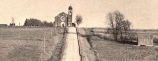
St. Luke's United Church of
Christ, stands astride the Iowa-Minnesota
boundary at the south edge of the little town of
Eitzen, Minnesota.
This view looks east along boundary road.
Allamakee county is at right.
|
 |
WHAT HAPPENED TO THE SUGAR
CAMP?
A few miles farther, the surveyors crossed
Waterloo Creek, which they described only as "50
links wide" (about 30 feet). This is now the
location of Bee, a tiny Norwegian settlement that
grew out of a flour mill on the Creek, the Sugar Bee
Mill. It is one of the prettiest spots along the
border. The creek flows fast and clear between rocky
banks in a narrow valley heavily forested with pine
and cedar. The creek has been stocked with trout, and
a fishing access is located at the bridge just south
of the border.
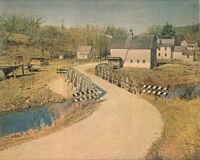
The tiny Allamakee settlement of Bee, where Waterloo
Creek crosses into Iowa from Minnesota.
The country rises sharply to the west and there is
this notation: "This post stands on the western
side of a high dividing ridge commanding a view of 12
miles east and west."
Allamakee County road Q now runs along the ridge
and the view is of the patchwork quilt of farmland on
both sides of the border. Another ridge was crossed a
few miles farthr west: "Top of high ridge
dividing the waters of Root River from those of the
Little Iowa (Upper Iowa) bears north-south; outcrop
of limestone." The ridge is just north of the
Winneshiek County community of Hesper. To the east it
is almost too steep to climb and the border road
makes a sharp detour into Iowa to avoid it.
Again there is this cryptic notation: "Range
8, Sec. 33, 65 chains: Enter sugar camp; 70 chains:
Brook, 6 links wide, runs northeast; 72 chains: Leave
sugar camp." The brook is still there but there
is no hint what the "sugar camp" may have
been. The date was May 4, too late in the season for
making maple sugar.
NOW THE TIMBER IS MOSTLY GONE
A few miles farther and they came to the Second
Azimuth Station, just east of where Prosper,
Minnesota, now stands and where U.S. Highway 52
crosses the border north from Decorah. The site is
now on the Byron J. Hanlon farm on the Iowa side.
Gently rolling hills and high, dry prairie gave
the surveyors little trouble until they came to the
first crossing of the Upper Iowa River in Range 10,
Sec. 31. They would cross it no fewer than eight
times in the next six miles, clambering down a cliff
on one side, up a cliff on the other each time. On
the first crossing, they noted: "River at this
point runs S.W. about 2 feet deep and 100 links (66
feet) wide, swift current; left bank perpendicular
limestone 80 feet high; no indication of
overflows." And again on same page:
"Surface east of river hilly, soil second rate;
west side level and covered with a fine grove of
timber, Elm, Lind, Black and White Oak, Burr and Red
Oak, Black and White Walnut, Sugar, Ash and Hackberry
with an undergrowth of same; this grove is large,
soil in it very rich, and well situated for farming
purposes. No appearance of overflow along river
banks." The timber is mostly gone now and most
of the river bottom is in pasture.
EXPEDITION SPlLIT UP INTO
SEVERAL PARTIES
From here, it was one river crossing after
another, past the present site of the twin border
towns of Florenceville, Iowa and Granger, Minnesota
to Station Washington, on the outskirts of Chester.
Here Talcott remained for several weeks, splitting up
his expedition into the individual parties and
augmenting his supplies. The location is on a low
rise and is now occupied by the Vernon Eggerich farm.
Eggerich's deed shows the farm was first homesteaded
in 1858 by Daniel Ballard. There is no trace of
Station Washington, either on the ground or in the
deed.
~Des Moines Sunday Register, Des Moines,
Iowa, July 12, 1970
~contributed by Errin Wilker
|