updated 06/16/2013
![]()
updated 06/16/2013
Little Switzerland of America Illustrated Map Enticing Drives and Trails Where Natural Scenic Beauty Abounds Compiled by |
.jpg) |
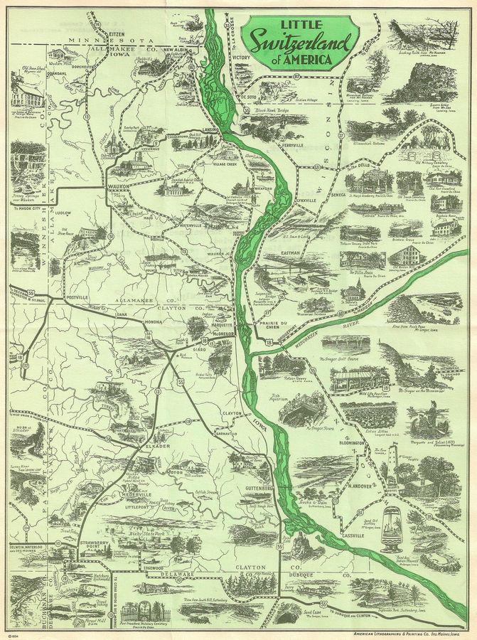
The illustrated map of Allamakee & Clayton counties was printed on the back of a letter sent out by the New Albin Savings Bank in 1935. It also was a part of a travel brochure, that included the illustrated map and the other photos on this page. Source credits can be found at the bottom of this page.
Little Switzerland of AmericaLarger versions of the image will open in a new window, or download the complete large image. Choose which section you'd like to view:
Top left (218kb) * Bottom left (198 kb) * Top right (220 kb) * Bottom right (207 kb) * Full map (4.18 mb)
~*~*~
LITTLE SWITZERLAND OF AMERICA
The land of Joliet and Marquette is one of ever changing scenery. Its lofty hills and rocky points burying themselves in the low hanging clouds offer panoramic views that are not excelled in any other section of the middle west.
So varied is the scenery and history of this section that every new mile one travels opens up still more entrancing and inviting views and spots rich in historic lore. One could spend several weeks in this section and then only barely skim the surface of the remarkable things that are here.
Travelers each year go many miles in search of things worthwhile to see and of which they can later tell their grandchildren. But no section is of greater interest to the people of the middle west than "The Little Switzerland of America", where the history of the entire middle west had its beginning. Each year sees more and more of these famous old landmarks and points opened up to the traveling public so that they can come back into this section and just lose themselves from the modern madly rushing world, to sit in deep thought and delve into the days gone by, and think of the great events that took place here.
The United States Government is constantly adding land in this section to the Wild Life Refuge, to make its hills and valleys a haven for the wild life that once roamed over this terrain. As one goes about in this section and thinks of the great men like Abraham Lincoln, Jefferson Davis, General Grant, Zachary Taylor, Julien Dubuque, Zebulon Pike, Chief Blackhawk and many others who here helped to make the early history of the middle west, it kindles a desire to see all of it and know more of its early history and romances.
Fishing and Hunting
This region offers the outdoor man every opportunity for a week's recreation. When fish are hitting, anglers bring in nice walleyed pike, black bass, small mouth bass, sunfish, crappie, perch, catfish, and rainbow trout. In winter, the hunter delights in running a fox or treeing a coon, both of which abound here.
Scenic Loop
One of the prettiest auto drives in the midwest, showing the rugged Mississippi river country at its best awaits the motorist. The loop can start at Marquette, go to McGregor, Monona, Postville, Waukon and Lansing on the Iowa side, or go up the river from Marquette to Waukon. At Lansing the motorist crosses the Father of Waters on The Blackhawk Bridge, and comes down an equally beautiful river road on the Wisconsin side, returning over the Marquette-Prairie du Chien bridge.
GUTTENBERG - “Where the Mississippi Waves to You".
Guttenberg originally settled by the French, was known as Prairie La Porte. Here was held the first District Court in the Territory of lowa. Prairie La Porte was the county seat of Clayton County when its boundaries extended to the Canadian border. ln the forties the Western Settlement Society colonized the town with Germans and changed the name to Guttenberg. Many of these people were German intellectuals who fled the military regime of the old country. Many of the buildings are of European architecture, some so distinctly and purely so that artists frequently make them subjects for their canvases. These structures are still occupied as businesses and residences.
Two miles of beautifully parked river front attracts tourists who universally declare that the views of the Mississippi river from front street and from the bluffs behind the city are unexcelled. The government is constructing the locks for Dam No. 10 of the nine foot channel project at Guttenberg.
The two paved hill roads leading into the city from the north and from the south afford breathtaking panoramic views of the town and river. There is a ridge road along the bluff behind the city that is a constant joy to those who travel it.
Until you have seen Guttenberg, with its unsurpassed river front, its old world atmosphere and its scenic beauties, you have not seen northeastern lowa.
Pioneer Rock Church at Ceres on highway No. 55 was formerly "St. Peter's German United Evangelical Lutheran Church". The congregation was organized in 1858 by the Dr. Paul Stockfeld.
The corner stone was laid on October 25, 1858, the building was built of native stone quarried at the Gerh. Bierbaum quarry. ln 1889 the present tower was built and bell installed. ln 1874 the first organ was installed. The last regular services were held in the church in 1907. ln 1927 an association for the restoring of the church was formed.
MARQUETTE
Marquette, for many years called North McGregor, was named after Father Marquette, who discovered the Mississippi near here in 1673. The town's 800 inhabitants are mostly interested in the Milwaukee Road, which has a division point here.
FIRST SETTLER IN IOWA—Bazli Giard, generally acclaimed Iowa`s First settler, had a plantation at Marquette in 1784. He petitioned for the title to the Spanish Grant, or Bazil Giard’s Claim No. 1, in 1800, the claim was not allowed until 1843. The grant included 5760 acres from the Mississippi at Marquette six miles west, including the Heights and Ridgewood, now part of McGregor. A rock monument in honor of Giard is being constructed in Marquette. Vistors add stones to the collection now several years old.
PONTOON BRIDGE—At Marquette the Milwaukee road has a pontoon railway bridge, the largest in the world. As the Mississippi waters rise and fall, the railway tracks on the pontoon (or floating) bridge are raised or lowered. There is a pontoon in each channel. They float open to allow steamers to pass through the bridge.
SCENIC DRIVE—Highway No. 13, an all-weather road, north of Marquette offers tourists the most scenic river drive on the Mississippi, traversing the wildest part of Iowa.
TROUT STREAM—Bloody Run, which divides the town of Marquette, is a Fine trout stream.
OAKCREST—Oakcrest is the bluff just north of Marquette. Summer cottages and an ideal picnic spot make it popular.
INDIAN MOUNDS—One of the best groups of Indian mounds in the world are located a few miles from Marquette. These mounds have not been disturbed and are easily distinguished for the animals they portray.
OLD MILITARY TRAIL—On Highway No. 13 north of Marquette, is the old Military trail, used by the soldiers at Fort Crawford traveling to Ft. Atkinson, Iowa. The D.A.R. have a marker showing the trail.
MARQUETTE—PRAIRIE DU CHIEN BRIDGE - SUSPENSION BRIDGE
The bridge at Marquette and Prairie du Chien is the only suspension bridge on the Mississippi river. lts twin suspensions are connected by a road across the islands. The bridge offers a wonderful view of the Father of Waters and its majestic, towering bluffs. The island sloughs have wonderful beds of the American Lotus Lily, blooming during the last weeks of July and the First weeks of August.
POSTVILLE
Postville is situated at the junction of highways No. 18, 55 and 51. Tourists will find here, a good hotel, fine restaurants and a camp ground.
THE OLD STONE HOUSE is located six miles northeast on highway No. 51. This three story building is maintained by the county as a park. lt is used as a picnic ground and a stopping place for the numerous fisherman who come here for trout which are so plentiful in the spring brooks flowing into Yellow River.
TROUT FISHING AND SCENERY—Annually thousands of adult Rainbow, Brook and German Brown trout are planted in these streams as are hundreds of fingerlings. The heavily wooded bluffs along the Yellow river offer a splendid opportunity for botanical surveys and study. For many years Bohemil Shimek and University of Iowa students came here for their summer classes and found rare specimens of plant life, some of which are not found in any other place south of Alaska.
SIDE TRIPS—Well maintained roads through Allamakee county hills and vales make side trips out of Postville an ever present happy allurement.
PRAIRIE DU CHIEN (Wisconsin)
The neutral meeting ground for Indians and white men for over two and a half centuries, Prairie du Chien teems with history, tradition, tragedy and romance of the dim and distant past. It was the outpost of the great unconquered northwest domain for 140 years.
FORT CRAWFORD—The American flag was first raised in Wisconsin at Ft. Shelby, in 1814. The fort was captured the following month by the British and the name changed to Ft. McKay. In 1815 it was evacuated and burned by the British. Fort Crawford was established in July of 1816. At the fort Dr. Beaumont, a surgeon in the U. S. army, performed experiments on Alexis St. Martin, which laid the foundation for our knowledge of digestion. An army, officer who attained the presidency of the United States and another who became president of the confederacy, General Zachary Taylor, and Lieutenant Jefferson Davis, were stationed at Fort Crawford in the early years of the 19th century. The last public use of Ft. Crawford was during the Civil War as a recruiting station. Only one wall of the Fort hospital remained standing until 1934 when the entire building was restored.
TRADING POSTS—Two old trading post buildings, the John Jacob Astor Fur Trading Post and the Northwest Fur Company`s storehouse, still remain standing. The old Hudson Bay Trading Post has been torn down.
VILLA LOUIS—This, famous home of H.L. Dousman, noted fur trader (one of the wealthiest men of his day in the U. S.) is now open to the public as a museum. This home was the scene of social functions unusual to frontier towns. A guide explains interesting relics of early days in the house.
STEAMBOAT DAYS—Relics of early steamboat days when grain was brought to Prairie du Chien, stored and shipped, are the long warehouse and grain elevator on the river. The railroad doomed this thriving and colorful business.
CHURCH AND CEMETERIES—St. Gabriel’s church, built in 1839, was organized in 1817 and was the first church organization in Wisconsin. The old Military cemetery was established in 1829. The Prairie du Chien Old French cemetery and Calvary cemetery also are famed burial spots. The Brisbois grave is high on Mt. Pleasant, the highest peak near Prairie du Chien. Tradition says Brisbois chose this spot in order to look down on his ancient competitor Joseph Rolette, prominent fur trader.
OLD INDIAN VILLAGE—East of the Gran Grae on highway No. 60 between Prairie du Chien and Wauzeka is an old lndian village and many Indian mounds, marked by the Wisconsin Historical Society.
COLLEGE AND ACADEMY—Campion Academy for young men and St. Mary's college for girls are both located in Prairie du Chien. They are catholic institutions.
NELSON DEWEY STATE PARK—South of Prairie du Chien is a Wisconsin State park, comprising 1,651 acres. It was from Lookout Point in this park that Marquette and Joliet First viewed the Mississippi river in 1673. Interesting earthworks, an Indian workshop, many Indian mounds—among them a procession consisting of fourteen conical, thirteen linear, and a single effigy mound are to be found in the park.
ELKADER
Elkader lies in a deep valley practically surrounded by hills, with the Turkey river dividing it.
Nearly one hundred years ago pioneers settled here on the banks of the river and ninety years ago they built a dam and a stone grist mill now used for feed grinding. The dam is now a modern concrete structure and the power generates electricity. Good roads enter Elkader from all directions, winding through the valleys or over the hills, with the stranger unaware of the proximity of the town until practically within its borders.
THE NATIVE STONE BRIDGE over the Turkey river at Elkader is unique. lt consists of two arches, each of 90 foot span, its pier and abutments bedded in the solid rock. Its arches are said to have the largest clear span of any bridge of this type in the world. From this bridge one can get a magnificent view of the river and dam, and the historic court house on the east bank. The Elkader Fair Grounds has a beautiful wooded tourist camp and picnic grounds. Artesian wells furnish the purest water.
SCENIC DRIVE—The trip from Strawberry Point to Elkader over paved highway No. 13 is most beautiful. Leaving Strawberry Point you ride a high ridge with wonderful views on either side. The road then takes you down a long grade and you wind through the valleys until you cross the Volga river, where you start the long climb to Chicken Ridge, the highest point in the country. From this ridge you can look for miles in any direction over picturesque valleys, winding streams and growing fields. Here you start a gradual descent through a canyon into Elkader.
SIDE TRIPS—One to the village of Mederville where the walls of the once busy mill on the Volga River are still standing. Another to Motor where an empty three story mill and the remnants of a dam in the Turkey river speak of days when that was a busy community.
Northwest of Elkader about six miles on the north side of Turkey river is The Big Spring, water from which doubles the size of the river at this point.
TABLE ROCK—Just a few hundred feet north of highway No. 13 three miles east of Elkader is Table Rock, from which it is said that the Declaration of Independence was first read in the State of Iowa at an early settlers picnic.
MONONA - BEULAH FALLS
When the tourist visits Monona, he is proudly directed to Beulah Falls, six miles east of town, just off Highway 18. Here is one of the best picnic spots in the section. A beautiful falls and spring are surrounded by a large playground area.
WAUKON
Radiating from Waukon are a number of enchanting drives, along circuitous paths with ever varying scenes.
To the north of Waukon is the Iron Mine, operated during the World War, but since abandoned. The mine produces a high grade ore, used in the manufacture of paint.
Passing the Iron Mine, one drives northward, turning off the pavement at Lycurgus church, and follows a winding road, along the Upper Iowa, correctly called the Oneota River bottoms, to New Albin, the most northeasterly town in the state.
Continuing along the pavement eastward past the Lycurgus church, you come to Landmark Inn, in olden days the Halfway House between Waukon and Lansing. Here farmers from as far west as Osage, and travelers found shelter during the night. The Inn was fortified a against, and prepared to resist Indian attacks, the building today still shows the precautions taken more than three quarters of a century ago.
PINNEY SPRINGS—Here in the cool, protected hillside, down which the water flows one may enjoy a picnic lunch, refreshed by a drink from the pure hillside spring. Pinney Springs is worth the time required to walk several hundred yards from the road.
INDIAN MISSION—In 1834, through the military authorities at Fort Crawford, an Indian mission was established along the Yellow River to Christianize and educate the Indians. The mission was one of the first established west of the Mississippi.
PAINT ROCK—Earlier called the "Painted Rock", along the Mississippi River in Fairview township, is a bold cliff, upon which as early as 1843, a figure of an animal, and the word "tiger", together with other names and symbols, were to be seen. It is believed that it was at this junction that the southern boundary of the "neutral ground" in 1830 touched the Mississippi.
Near the mouth of Yellow River, only a few miles from Prairie du Chien, Jefferson Davis, later president of the Confederacy, constructed a dam in Allamakee county, a few remains are still to be seen.
WAUKON, chief city of Allamakee county, was first settled in 1849, first served by a railroad in the fall of 1877, and is now served by good roads. The city was named for John Waukon, a prominent chief of the Winnebago Indian tribe.
Highway No. 13 follows a northerly course from Waukon over happy, rolling hills to the Minnesota line near Eitzen.
Allamakee county affords excellent trout fishing—probably the best in Iowa. There are numerous trout streams within a half hours ride of Waukon, and many trout await the tantalizing fly.
McGREGOR
McGregor, surrounded on three sides by heavily wooded bluffs and on the fourth by the mighty Mississippi, is the hub of "The Little Switzerland of American. Several days can be spent here, viewing the wonders of nature. McGregor at one time was the rival of Chicago. From 1840 until the coming of the railroads, McGregor was the great Mississippi river shipping point for grain and produce from the western prairies.
INDIANS—Within a radius of 15 miles of McGregor there are 10,000 long, round, animal, reptile shaped effigy mounds, fortification and earthworks. Some mounds are 300 feet long, the shape of birds, bears, wolves, serpents and symbols can be easily traced on the ground. Northeastern lowa and southwestern Wisconsin was for ages the favorite habitation of the Red Man.
WILD LIFE SCHOOL—Started in 1919, McGregor annually strives to teach a better understanding and a higher appreciation of nature subjects and conservation. The town maintains a pavilion on The Heights and each summer, the first two weeks of August, leading professors and instructors of botany, ecology, geology, ornithology and conservation from the best midwestern colleges, universities and museums donate their services. The Wild Life Refuge movement started in this school.
THE HEIGHTS—This bluff towering over the Mississippi has a good hotel, fifty summer homes, an observation tower 500 feet over the Mississippi, where three states can be seen. Picnic grounds and tennis courts are provided.
PIKE’S PEAK AND PICTURED ROCKS—South of McGregor is a famed picnic spot and tourist attraction. Here Zebulon Pike, a U.S. General considered building a fort, later building it at Prairie du Chien. He discovered Pike’s Peak in Colorado. A wonderful panoramic view of the Mississippi is offered at the Peak. Down the ravine from Pike's Peak are several beautiful waterfalls, a sand cave and "Pictured Rocks", colored sands. Here every color known except blue is found.
SAND ART—Andrew Clemens, the greatest artist the world has ever known using colored sands for working material, spent his entire life at McGregor. He developed the art of using the Pictured Rocks sand in bottles, for designs. Bottles are on display in McGregor. These sand pictures resemble oil paintings. The grains of sand are loose, placed in the bottle upside down, a grain at a time. Other artists have drawn their pictures in sand frames, using glass to show background. Their work is crude in comparison, but nevertheless very worthwhile.
RINGLING BROS. CIRCUS—The famous Ringling Brothers Circus started from McGregor. The five brothers gave their first penny circus in the back yard of the lot just south of the Tourist Park.
LOTUS LILIES—ln season, the last of July and the first of August, great lotus beds bloom near McGregor. Within a mile from the mainland is a bed half a mile long and other great beds of the American lotus are accessible.
EXCURSION AND PLEASURE BOATS—Several boat lines operate out of McGregor. The ELK is very popular for its scenic trips. It carries up to 100 persons, while small boats are available for parties and fishing trips.
AQUARIUM—ln McGregor, a small aquarium features Mississippi river fish and marine life. A clam shell, lndian exhibit, furs, stuffed birds, and other interesting articles are on display here. The proprietor is the largest fresh water pearl buyer in America.
BIRD MUSEUM—Five miles out of McGregor, on Highway 18, is a collection of over 700 species of birds, many of them local. The owner is a recognized ornithologist.
GOLF COURSE—McGregor has a 9 hole scenic golf course on the hilltops, 400 feet over the river.
STRAWBERRY POINT
Located at the junction of paved highways Nos. 10 and 13. Beginning south of Strawberry Point and extending northward is the greatest array of scenery in the state, winding drives following ridges and valleys leave a lasting impression.
WHOLE MILK CREAMERY—One of the largest whole milk creameries in the U.S. is located at Strawberry Point. More than 23,000,000 pounds of milk are handled annually, from which over a million pounds of high scoring butter is made. Visitors are welcome at this plant. The 100 foot flagpole at the city hall is where Wm. Penfield made a 60 day record as a flagpole sitter. Near the business section is a completely equipped tourist park. East of town is one of the most beautifully landscaped cemeteries to be seen anywhere.
THE BACKBONE STATE PARK, lowa’s first and largest, embracing more than 1,400 acres, is located 3 miles south of town. At the north end, is Richmond Springs and stream, a favorite spot for trout Fishermen, also for picnicking. Nearby is the state fish hatchery, with cold running water piped From Richmond Springs. Thousands of trout are raised here annually and placed in trout streams of northeast lowa. Close by is a huge balanced rock, and a cave that extends Far back under a rock cliff. A wide road leads southward through a dense forest, to a large flat picnicking area. Many trails have been built leading to places of interest. Crossing the Maquoketa river to the “Backbone" from which one is greeted with gorgeous panoramic views.
The “Backbone" is a high rocky ridge around which the river forms a loop. At one place the ridge is but a few feet wide, with a sheer drop of almost 100 feet on either side. West of "Backbone" and located far above the floor of the valley is the custodians lodge and the C.C.C. housing several hundred young men engaged in park work. At the extreme southern boundary a large dam is being constructed across the Maquoketa river, making an artificial lake covering 300 acres. This lake will be stocked with game fish. Camping is permitted.
JOY SPRINGS and KLEINLEIN MILL—Three miles west and a mile south of Strawberry Point is a favorite picnic grounds, "Joy Springs". Many springs flow into the Maquoketa river at this point, and the stream is stocked with trout. Two miles north is Kleinlein Mill, formerly a thriving settlement. Huge stone buildings still remain, the mill has long been abandoned. The spring-fed stream is stocked with trout, and excellent catches are reported. The views from the valley are unsurpassed. Highway No. 13 to Elkader will prove to be most enjoyable and of great scenic interest. This drive is considered one of the most beautiful in northeast lowa. Northeast of Strawberry Point unlimited rugged scenery abounds, countless valleys and secluded scenic areas.
You will find Strawberry Point ideal headquarters while making a casual visit or an extensive tour of the section. The town boasts one of the best hotels in the territory.
BIXBY’S PARK—One of the rarities of nature, in the form of an ice cave, is found at Bixby’s Park, two miles north of Edgewood, 10 miles southeast of Strawberry Point on Primary No. 10. Bixby's Park, state owned, contains 69 acres, abounding in the rustic beauty, rock cliffs, clear spring-fed streams, and wooded hills. The outstanding attraction is the ice cave in which a temperature of 29 degrees exists the year round. The ice in the cave reaches almost to the entrance, and when approaching the visitor is struck with sudden temperature change. A large picnic area centers about an old log cabin, tables and benches are provided. Many picnickers get ice from the cave and make ice cream at the park.
EDGEWOOD —SIDE TRIPS— To the east and north will prove most interesting. Primary No. 10 leading to Luxemburg via Colesburg is a scenic drive that will long be remembered. Springs, waterfalls, old mills, and several rail fences are sights located near Edgewood.
LANSING
"The Picture City", with its historic and scenic environments, is where every visitor should spend some time. It is in the midst of "vacation land", with beautiful and interesting places in every direction.
Coming to the city from the west, Highway No. 9, leads for seven miles down a winding valley over the "Road of a Thousand Curves", and at every turn is a new vision of Natures beauty. At the western edge of Lansing the road passes the beautiful Gethsemane cemetery, while directly across the valley is Oak Hill cemetery, remarkable for its columnar arborvitae.
The eastern gateway to Lansing is the beautiful new thirty ton Blackhawk bridge over the Mississippi, connecting with improved roads through a wonderfully scenic section to Wisconsin points north, south and east.
Lansing nestles along the southern base of Mt. Hosmer, a bold promontory rising abruptly nearly 500 feet above the river level. Crowned with Indian mounds, and a 55 acre park dedicated to Lansing’s "Soldiers of All Wars", with its three jutting crags named for the three Lansing boys who were killed during the World War. A good auto road leads to the summit from which panoramas of wonderful scenic beauty unfold before the eye, of the Majestic "Ol' Man River", "jest a rollin’ along; the thousands of acres of island wilderness of the original "Winneshiek Bottoms", where wild life abounds; its lakes and winding channels shaded by lofty elms, the town and the Blackhawk Bridge; to the south stands the picturesque cliff of Mt. Ida and beyond is the Lovers’ Leap palisade with its legend of the Indian maiden.
SIDE TRIPS—One may drive south past Mt. Ida and Lovers’ Leap and then up the Village Creek valley to the old village of early days. Farther up the valley the Swedish Baptist settlement and church, the oldest, of the denomination in the United States. Another trip, up river, will take the tourist past the lotus beds, and an Indian village to an interesting group of Indian mounds.
GABBET’S POINT —On the road to New Albin, one passes under the frowning crag of Gabbet s point, a lookout at the time of the Fight of Battle Island during the Blackhawk War.
Swinging up the Oneota (Upper Iowa) valley, we Find the Sand Cove country. Elephant mountain, the old stone house that served as a neighborhood fortress in the time of Indian troubles, Mt. Hope church and cemetery, the English Bench settlement and quaint sequestered Dorchester.
Another trip takes one by a scenic route to Wexford church, the oldest Catholic church north of Dubuque, Founded by Trappist monks.
Across the Mississippi river from Lansing, near De Soto, are the remains of an Indian village, and here one may buy baskets woven by the squaws of the Indians who follow an age old occupation.
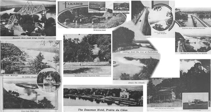
Clockwise from top left: Mammoth Black Hawk Bridge, Lansing; The Big Spring Elkader; Winter scene; Leap from Kramer's Hill; On No. 13 north of McGregor; View of Mississippi from Marquette; Suspension Bridge from Prairie du Chien; Suspension and Pontoon Bridge from Marquette; inset: S.S. Arbutus, McGregor; Gabbit's Point and Cabin North of Lansing; The Dausman Hotel, Prairie du Chien; View from Pike's Peak; circle inset: Catfish Slough; Pike's Peak, McGregor
Center left: Richmond Springs, Backbone Park
Center top right: Looking down the river at Guttenberg
Center bottom right: Above the Clouds
~*~*~
Sources:
Illustrated map ©1934 by American Lithographing & Printing Co. Des Moines, Iowa; printed on the back of a New Albin Savings Bank letter, dated 1935
Travel brochure, Compiled by The Northeastern Iowa Press Ass'n Travel Bureau Elkader, Iowa
~all photos were scanned from either the bank letter or from the brochure by Errin Wilker
~transcription of the brochure by Errin Wilker for Allamakee co. IAGenWeb
~*~*~
News
article about this map
Return to Land Records Index or
to Misc. Historical Records Index